


- Area
- Pureora Forest Park
- Distance
- 85km
- Time
- 2 days by bike; 4-5 days by foot
- Grade
- Easy/Moderate
- Access
- North: from Te Kuiti, head southeast on SH30 for 55 km. Turn right into Maereroa Road, then left onto Barryville Road. The Pureora Field Centre is 2.5 km along this road. South: at Ongarue, turn right twice to Mangakahu Road. Shuttle transport is available.
- Map
- BF34, BF35, BG35
- Notes & Map
- Timber Trail, Pureora Forest Park (pdf, 2 MB)
- GPX File
- Pureora Timber Trail (gpx, yo 126 KB)
- Your device does not support GPX files. Please try a different device.
The Timber Trail is an 85km walking and biking path stretching from Pureora Village in the north to Ongarue in the south. Utilising historic bush tramways, old bulldozer and haul roads, and newly constructed track, it passes through impressive native forest as well as some exotic forestry and open vegetation, offering extensive views of the surrounding landscape.
With reasonable fitness, you can comfortably ride it in two days. For tramping, double that at least. You may wish to bike the northern half (40km), and walk the southern half (45km) over 3-4 days, with one important proviso: starting at the northernmost end of either half will save a lot of arduous climbing.
It begins in the picturesque Pikiariki Ecological Area, about 200m east of the Pureora Visitor Centre. A boardwalk is crossed before the track winds through tall podocarp up to 800 years old. Listen out for birds here, especially kaka. After 3km, a sidetrack leads to an historic Caterpillar crawler tractor used to recover fencing material from totara logs during the 30s and 40s.The track crosses two roads before winding through toitoi, cabbage tree, five finger and kamahi regenerating after milling. It crosses Tui Rd and, after a gentle climb, reaches ,red shed, shelter, where there are expansive views to the west.
Carry on up the steeper flanks of Mt Pureora to the track’s highest point. The cloud forest and two epic bridges, over Bog Inn Creek and Orauhora Creek, are stunning. It is 40km to the spacious Piropiro Flats camping area.
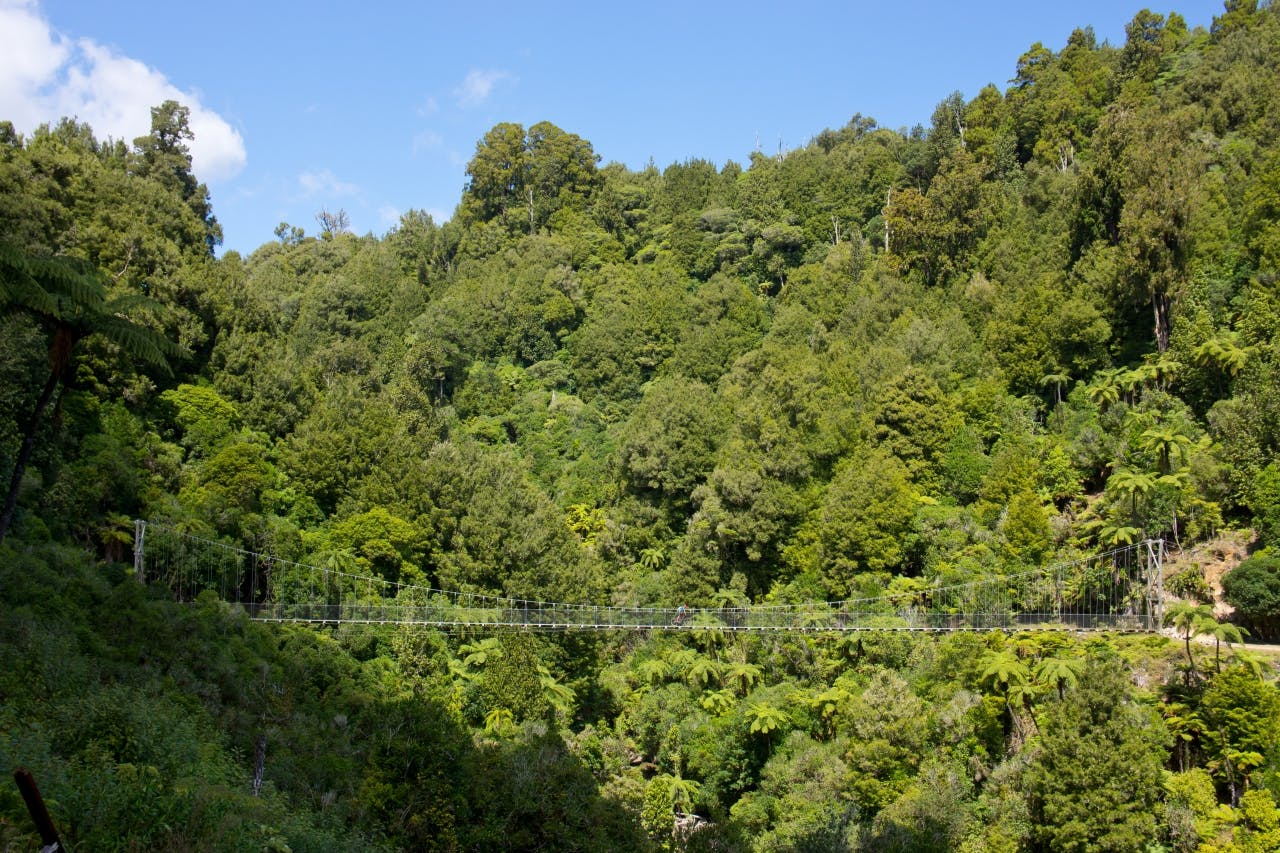
Beyond Piropiro, the first highlight comes relatively quickly – the magnificent Maramataha suspension bridge, one of the longest (141m) and highest (45m) single-spans in the country. Over the bridge, the steepest climb on the trail leads to what was the northern end of the Ellis and Burnand tramline.
From this point on, the past becomes the basis of a fascinating journey into history and heritage.The old tram route winds through picturesque natural bush, with numerous cuttings, embankments, stream crossings, cliff ledges, old huts and frequent interpretative panels. And happily, it’s mostly downhill all the way.
The Ongarue spiral is one of the most spectacular sections, a marvel of engineering comprising a lower-level bridge, a very deep cutting, a curved tunnel and an over-bridge.
The final few kilometres to the car park seem bland by comparison.
