


The Moss Pass route showcases some of the best the Nelson Lakes has to offer.
To circumnavigate the rugged Mahanga Range in the heart of Nelson Lakes National Park, with forested valleys, crystal clear lakes and snow-capped peaks, is strenuous but also incredibly rewarding.
The Moss Pass route heads over sub-alpine terrain between the Sabine and D’Urville valleys and takes four-to-five days. These two large watersheds drain into the head of Lake Rotoroa, the park’s largest lake.
Most choose to begin the trek by taking a water-taxi from Rotoroa to the lakehead and then walking from either the Sabine or D’Urville huts. However, you can also reach the huts from St Arnaud via the Speargrass Track (Lake Rotoiti) or the Mole Saddle Track from the lower Matakitaki Valley. Either route will add another day to the trek.
The Sabine is heavily forested with few large open flats, while the D’Urville has extensive areas of grassy flats in its mid-to-lower sections and snakes through the high summits of the Mahanga, Travers, and Franklin ranges. Beyond the Sabine Forks, where the Te Araroa Trail joins from the east, the valley climbs steadily to Blue Lake Hut and the stunning spectacle of Blue Lake. Lake Constance, beyond the moraine dam above Blue Lake, makes a great side trip. It is one of New Zealand’s largest alpine lakes and fills a deep post-glacial basin beneath the Mahanga Range and is on the route to Waiau Pass.
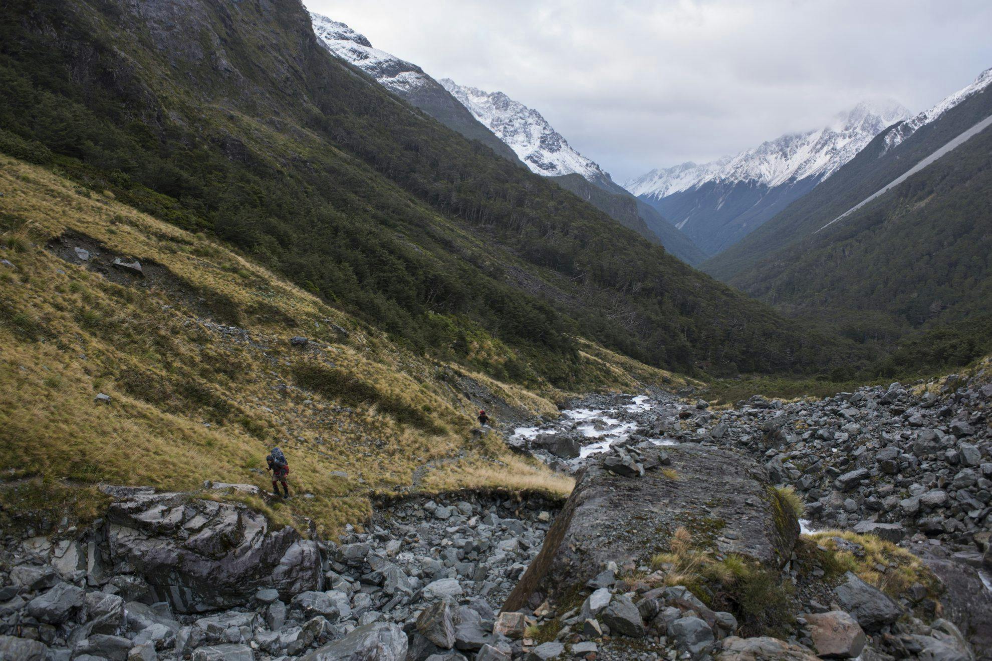
From Blue Lake Hut, a poled route leads to Moss Pass at 1785m. However, it should not be underestimated – it is steep, bluffed, and subject to extreme avalanche danger during winter and spring and is sometimes impassable at these times. My first trip to Moss Pass was during winter and we had to retreat from the basin below the Sabine face due to avalanche danger. Some of these avalanches had run well down into the bush and had blocked off the Sabine with masses of debris.
It’s a long and tiring descent to the D’Urville Valley, but the track from the valley floor is an easy and pleasant walk, alternating between lush tall forest and spacious grassy clearings. There are two huts in the valley before the exquisite lakehead setting of D’Urville Hut. This hut marks the end of the hike, but it is worthy of a night’s stay to imbibe the serene beauty of the lake, wetlands, and forest backed by the soaring faces of the Nelson Lakes tops. A fitting finale to a grand trek.
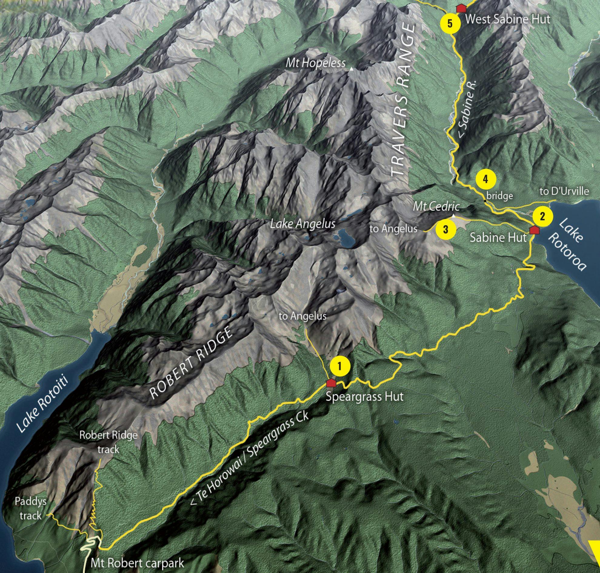
1. Speargrass Track
From Lake Rotoiti, the Speargrass Track provides access to Sabine Hut.
2. Sabine Hut
Marking the beginning of the Moss Pass trek, the large and comfortable Sabine Hut is right on the shore of Lake Rotoroa with a jetty for boat access.
3. Mt Cedric side trip
Directly behind Sabine Hut, a steep bush track heads to the open tops on Mt Cedric and Lake Angelus, which could be used as another way to access or exit the Moss Pass route. This would most likely add another day or two.
4. Sabine River footbridge
A scenic view over the deep, narrow chasm on the Sabine River, not far from the lakehead.
5. Sabine Forks
The forks mark the junction for the Travers Saddle route to Lake Rotoiti and where the Te Araroa Trail intersects the Moss Pass trip. The West Sabine Gorge, not far along this route, is impressive. The 30-bunk West Sabine Hut is also here – a good option for the second night of the trek.
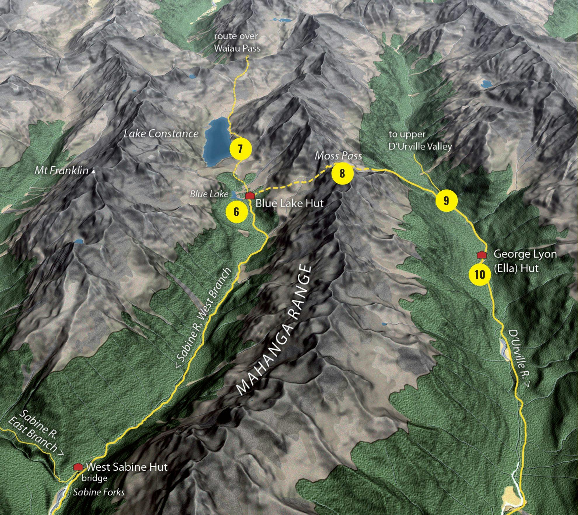
6. Blue Lake
One of the highlights of the trip, Blue Lake’s luminous blue waters shimmer beneath the steep flanks of Franklin Ridge and Mt Franklin, 2340m, the highest summit in the park. The lake is reputed to be the most optically pure in the world.
7. Lake Constance
Sombre Lake Constance fills a large trough beneath Waiau Pass and is certainly worth the two hour return excursion up the moraine wall from Blue Lake Hut to view its deep, clear waters.
8. Moss Pass
Moss Pass, 1785m, straddles the Mahanga Range just 600m above Blue Lake and in good conditions it can be reached in about two hours. There is a steep, rocky couloir to ascend just before the top. This can sometimes be snow-filled.
From the pass, it is a long 4-5hr descent to the floor of the D’Urville, so don’t underestimate the time it takes to get down the western side after the relatively short scramble up from Blue Lake. The track is well poled and marked and has great views above the bushline.
9. D’Urville Valley
Deep, long and beautiful, the D’Urville rises in the Spenser Mountains before draining into the head of Lake Rotoroa. Heavily-forested and with only short gorges, it also has many pleasant grassy flats below George Lyon Hut.
10. George Lyon Hut
This 16-bunk mid-valley hut is where most parties stay before or after crossing the pass and is set on a small flat about an hour downstream from the D’Urville River footbridge.
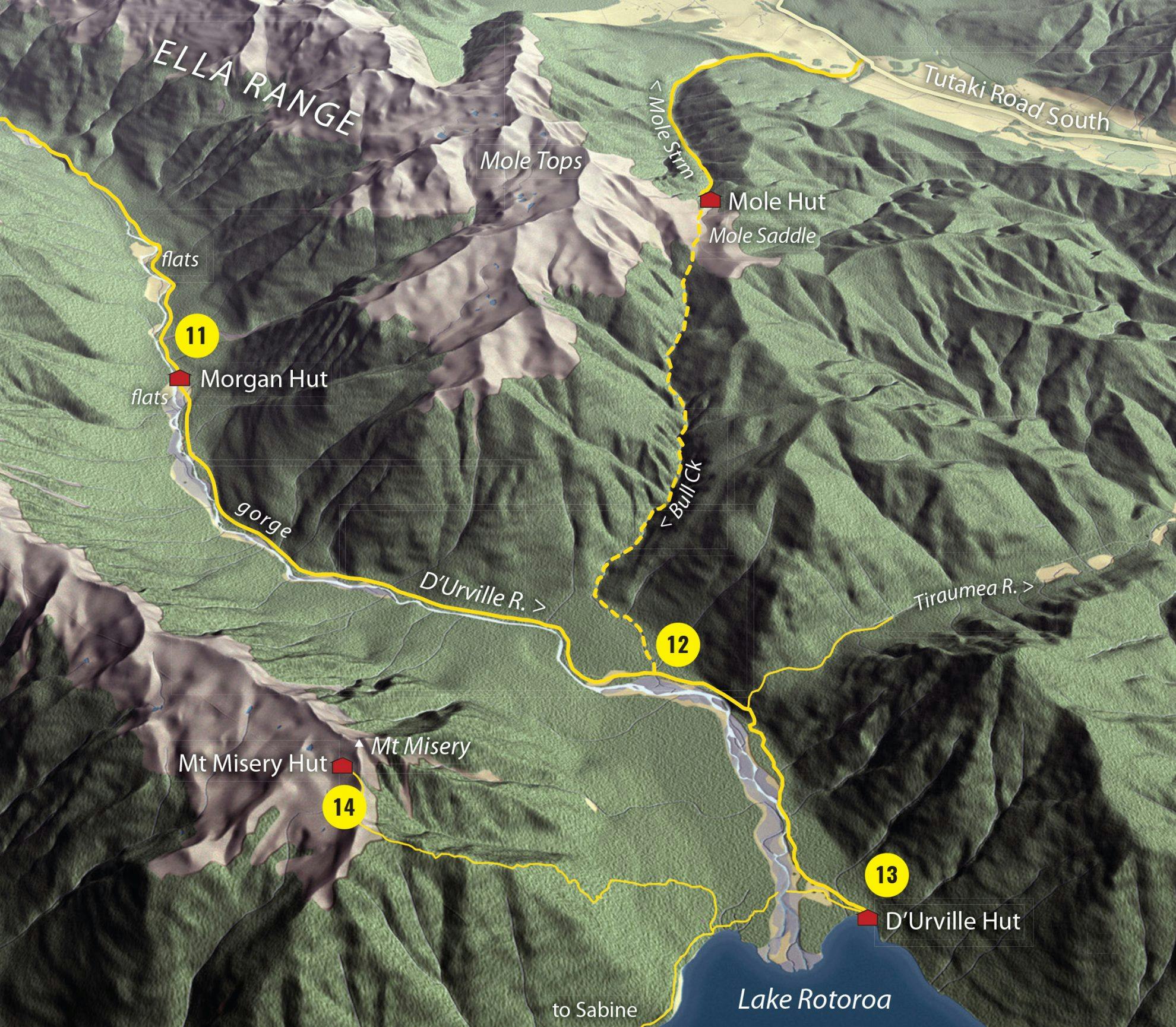
11. Morgan Hut and flats
Morgan Hut has a great setting on a large grassy terrace away from the river and is very peaceful with an outlook over the lower valley and Mahanga Range.
12. Mole Saddle-Tiraumea Track
The Track to Mole Hut provides another route in or out of the D’Urville Valley. NOTE: Though the map above shows the route heading up Bull Creek, this route is no longer passable. Trampers should take the Tiraumea Track to Tiraumea Hut and then take the Mole Saddle-Tiraumea Track on to Mole Hut.
13. D’Urville Hut
With its memorable lakeside setting and boat jetty, from which you could fish, D’Urville Hut is a peaceful place to spend a night and enjoy the early morning, or late evening light across the lakehead and Travers Range.
14. Mt Misery Hut side trip
If you have a day or two extra, a side trip to Mt Misery and its bivvy, perched at 1500m, is a rewarding excursion offering fantastic views over Lake Rotoroa, the Mahanga and Travers ranges and Buller Valley.
- Distance
- 45.4km
- Total Ascent
- 2195m
- Grade
- Moderate
- Time
- 4-5 days
- Accom.
- Sabine Hut ($15, 32 bunks), West Sabine Hut ($15, 30 bunks), Blue Lake Hut ($15, 16 bunks), George Lyon Hut ($5, 16 bunks), Morgan Hut ($5, 10 bunks), D'Urville Hut ($5, 10 bunks)
- Access
- Lake Rotoroa Village on Gowan Valley Road off SH6 west of Kawatiri Junction
- Map
- BS24, BT24
GPX File
- Moss Pass (gpx, 95 KB)
GPX File
- Your device does not support GPX files. Please try a different device.
