


Shaun Barnett visits one of the North Island’s best tramping destinations
To mark Wilderness magazine’s 30th anniversary, current and past editors and contributors scoured the archives for the 30 best trips we’ve published over the decades. This story, original published in January 2020, was included. You can find all 30 of the greatest Wilderness trips in the October 2021 issue.
We meet Joe Nawalaniec at the shelter, a concrete block affair named after Hawke’s Bay hunter Lester Masters. My two lads, Tom (15) and Lee (13), are disappointed not to find Sushi and Floyd, Joe’s two dogs, with him. After all, that had been part of my bribe to entice them on a four-day tramp in the northern Ruahine Range.
“Sorry boys,” Joe says. “The mutts are up ahead with Vicky and Kate.”
From the farmland, the Ruahine foothills rear up in an unforgivingly steep escarpment, up which you toil when your pack is heaviest. It’s been 30 years since I’ve walked up Golden Crown Ridge. Then, I was near the same age as Tom is now. It’s hard to recall many details from that long ago, but it seems the bush has regenerated, making a slow but steady transition from burnt scrub to thin forest.
At the top of the ridge, the gradient eases and at Aranga Hut we finally catch up with Vicky, Joe’s partner, and their friend Kate, who make up our party of six. Not counting the four-legged trampers. Floyd, a woolly black spoodle, has his saddlebags on. No free ride for this pooch; he has to carry his dinner. Sushi, an older huntaway-fox terrier cross, near retirement, gets to roam unencumbered.
Aranga Hut has seen better days. Beyond the derelict hut, we push on: our destination the fabled landscapes of Ruahine Corner.
I’ve approached Ruahine Corner from four different angles: the south-west, east, south-east and, once, from the air. One Christmas day, a pilot friend flew me there in his tiny Piper Club and we landed on the nearby airstrip for a quick visit.
We won’t make it to Ruahine Corner today though.
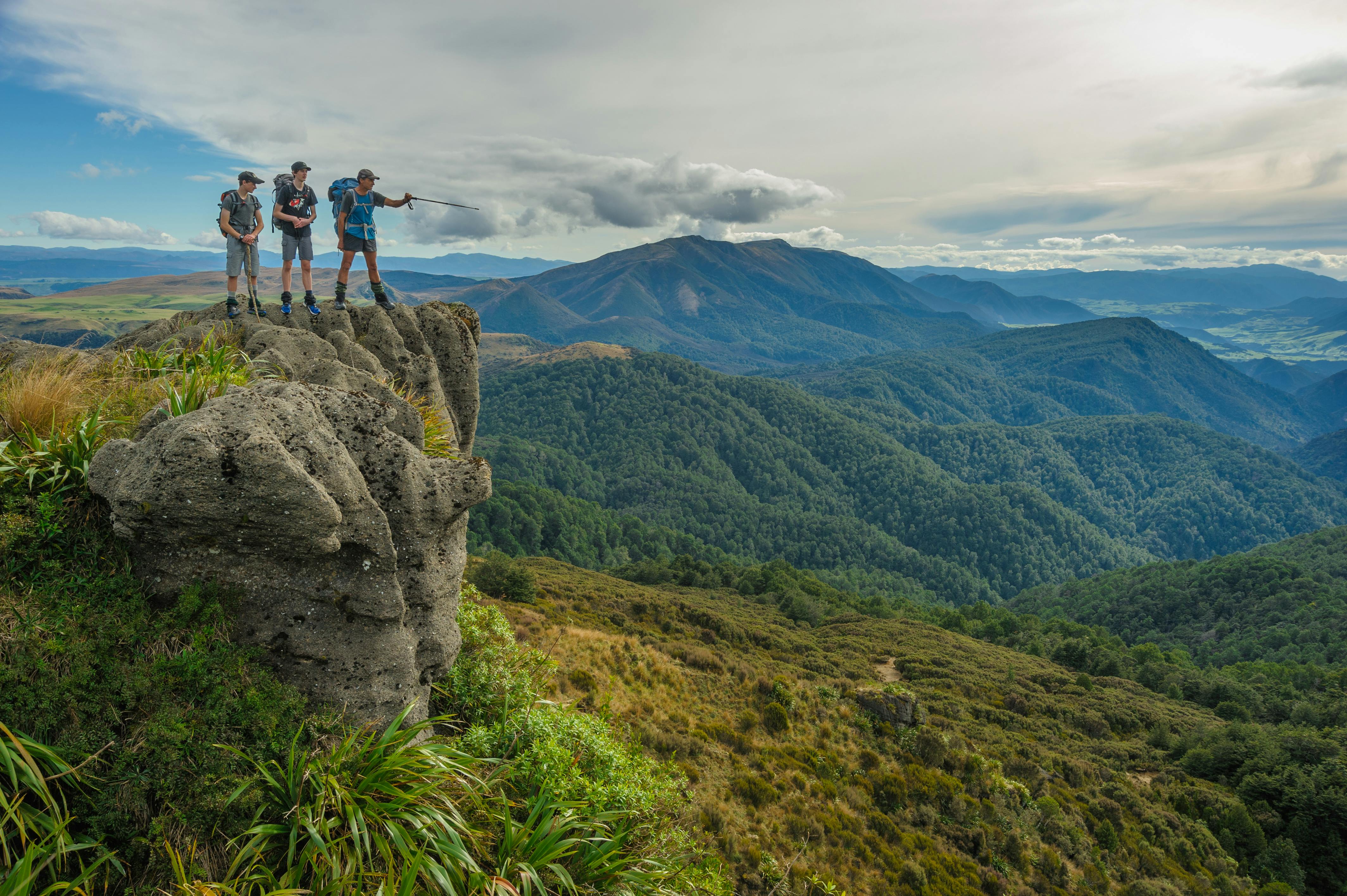
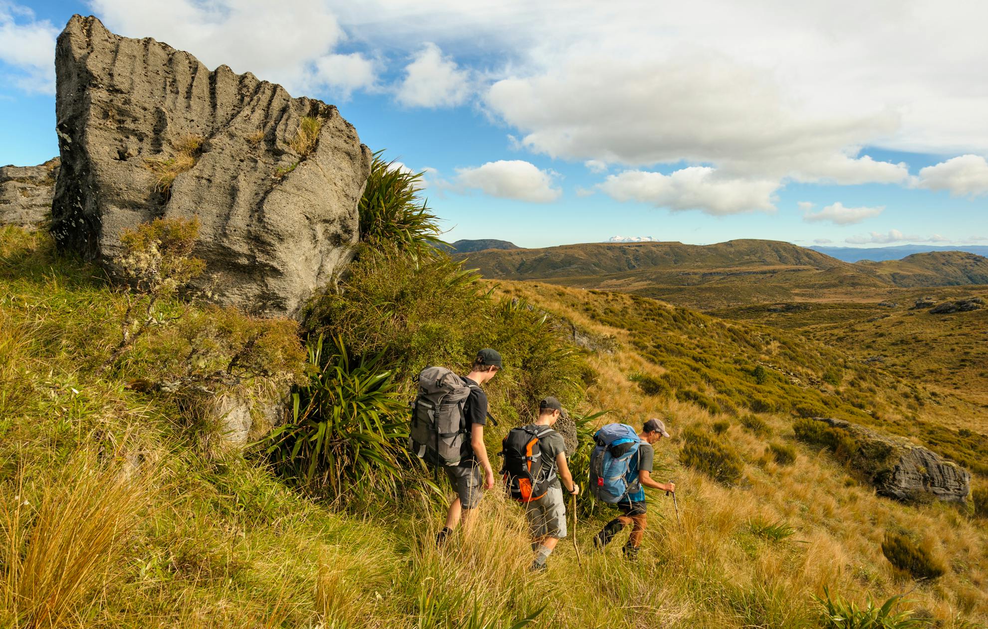
First, we have to traverse a flat tableland of tops following a poled route through the remnants of a forest that was burned in the relatively recent past. A few bleached stumps remain in places. Hard to believe, but early in the 20th-century sheep grazed these tops. Here, the range is barely above the natural bushline, and makes for easy travel, excepting one short push through scrub.
It’s a glorious autumn day: Ruapehu glistens.
By now we can see the expanse of the Mangaohane Plateau, on the edge of which sits Ruahine Corner Hut. A few late flowering gentians grace the tussock, and I introduce the boys to the bounty of autumn – ripe, white snowberries.
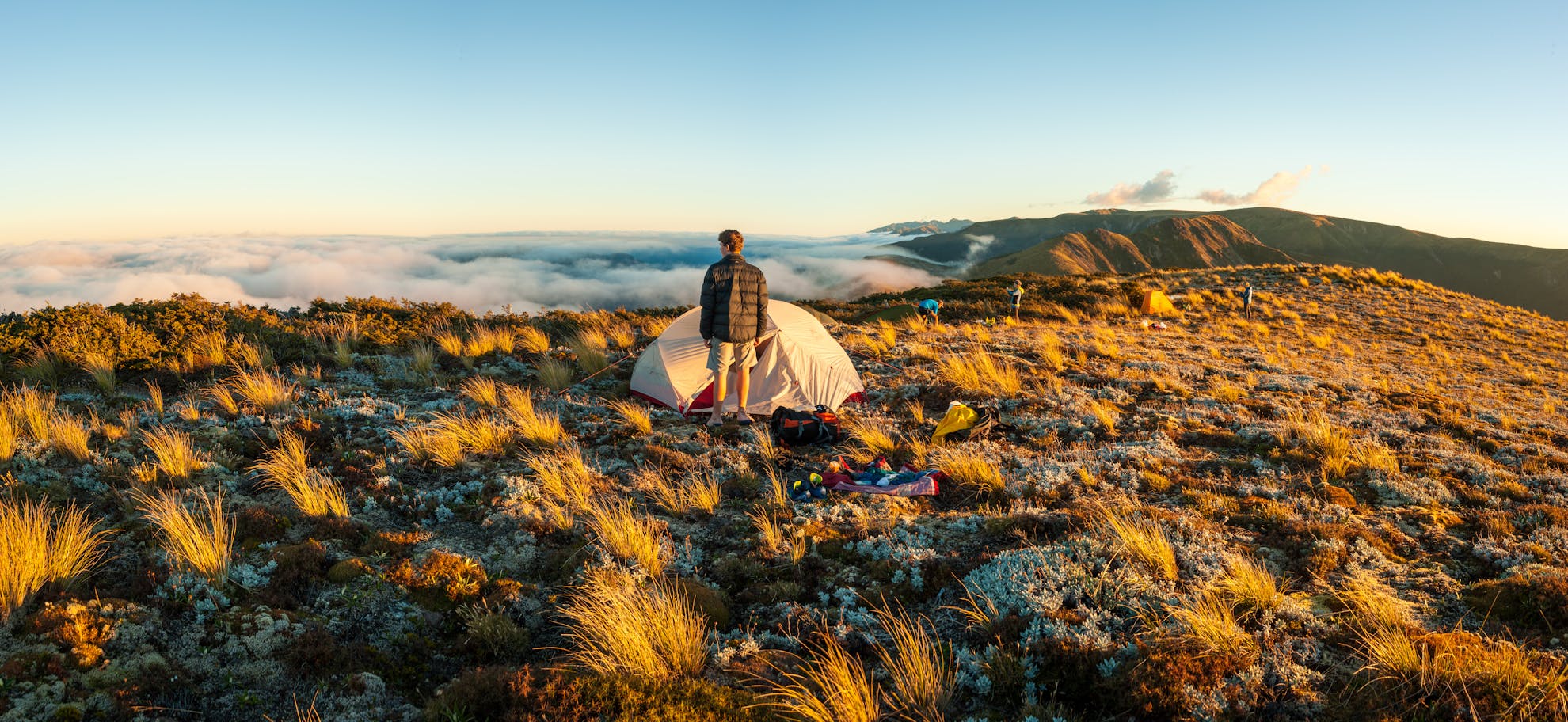
By sunset, we’re nestled in four tents, near some tarns, watching the colour in the sky deepen.
Morning. No frost but it’s chilly anyway. Slapping of hands, a spluttering primus, brewing tea, clasping steaming mugs. Waiting for the sun, which appears eventually, seemingly reluctantly, after its slow haul over the autumn horizon. Ah, the welcome light and warmth. Then, packed up, we’re tramping on, up to Piopio and beyond, over a strange crusty surface, where a myriad of tarns cluster among the alpine wetlands and sticky sundews finger upwards to catch foolish flies. I tell the boys of being lost here once in a dense mist. Despite several attempts, we’d failed to find the track heading west, given up and gone home with our tail between our legs.
This time, two of our number actually have tails, and both are being wagged enthusiastically. Tom and Lee are delighted to have the dogs with us; wee companions that never complain, talk too much or get grumpy. And they provide a constant topic of interest. ‘Where’s Floyd now?’ ‘There he is, he’s got bidi-bids in his eyebrows!’ ‘Come here Sushi, you need a pat.’ ‘Don’t lick my face!’
The day is still young when we find the track that descends to a bush saddle before Potae, then climb up to a limestone-fringed ridge. Good travel on flat terrain through forest leads towards the Mangaohane Plateau, and then suddenly we’re out of the forest on the edge of rolling tussock lands. Blinking in the sudden sunlight, the sky huge above the red plateau.
Ruahine Corner: I love this place.
There’s nowhere else in the Ruahine Range remotely like it; the expansive red tussock, rolling away to unseen bluffs, and the stark edge of the forest, where the conical, dark-topped pahautea trees stand like sentinels or curiously indigenous Christmas trees. And then there’s the north-facing hut, painted eggshell blue, with its large sun-welcoming veranda. Over the last decade or so, the hut has been expanded to accommodate conservationists working to protect the local kiwi population.
By the time Joe has toasted sandwiches in the hut’s frypan, and we’re enjoying our second brew, no one is fooled into thinking we will stick with the original plan to carry on today. The weather is too nice, the hut is too good, and we’re too lazy. We’re comfortably cornered. Ruahine cornered.
Kate reads a book. The dogs sleep on the veranda. Lee climbs one of the pahautea. We watch the sun arc across the sky until it falls behind the distinctive bluff of Te Rakaunuiakura.
Dinner is a mixture of what we’ve brought, and food generously left in the hut. I cook a chilli con carne, Joe rustles up a potato-kumara risotto, and Kate prepares a delicious fresh salad with blue cheese and apple. Desert is a butterscotch pudding and Whittaker’s chocolate. It’s a feast. Even the teenagers are stonkered.
Vicki decides to camp and demands to use Floyd as a sort-of substitute hot water bottle at the bottom of her sleeping bag. Having had similar thoughts himself, Joe concedes only reluctantly. Floyd seems happy with either arrangement.
It’s taken me 30 years to cover most of Ruahine Forest Park. I’ve walked every section of tops, bar a few side spurs, most sections of the main rivers, and visited all but a handful of the 70-odd huts. Still, my knowledge of the park is not half as good as some; the late Tony Gates knew the range intimately and had his own pet names for various places. Local trampers Jean Garman and David Harrington have systematically explored virtually every creek from tops to park boundary.
About six years ago, Carterton-based Joe had asked me for a list of good Ruahine locations, having almost exhausted the Tararua Range of fresh tramping opportunities. Since then, he’s built up a handy knowledge of the Ruahines, including visiting a few obscure huts that have eluded me. Ikawatea Forks Hut, for example, where we are next headed.
After a frosty start, we wend our way through the tussock, following a meandering route that leads to the trig beacon at Makirikiri. We pose for a group photo. The sun shines. All is good in the world.
Limestone bluffs fall away into the Ikawatea catchment, reminiscent of the great limestone-edged plateaus of Kahurangi National Park.
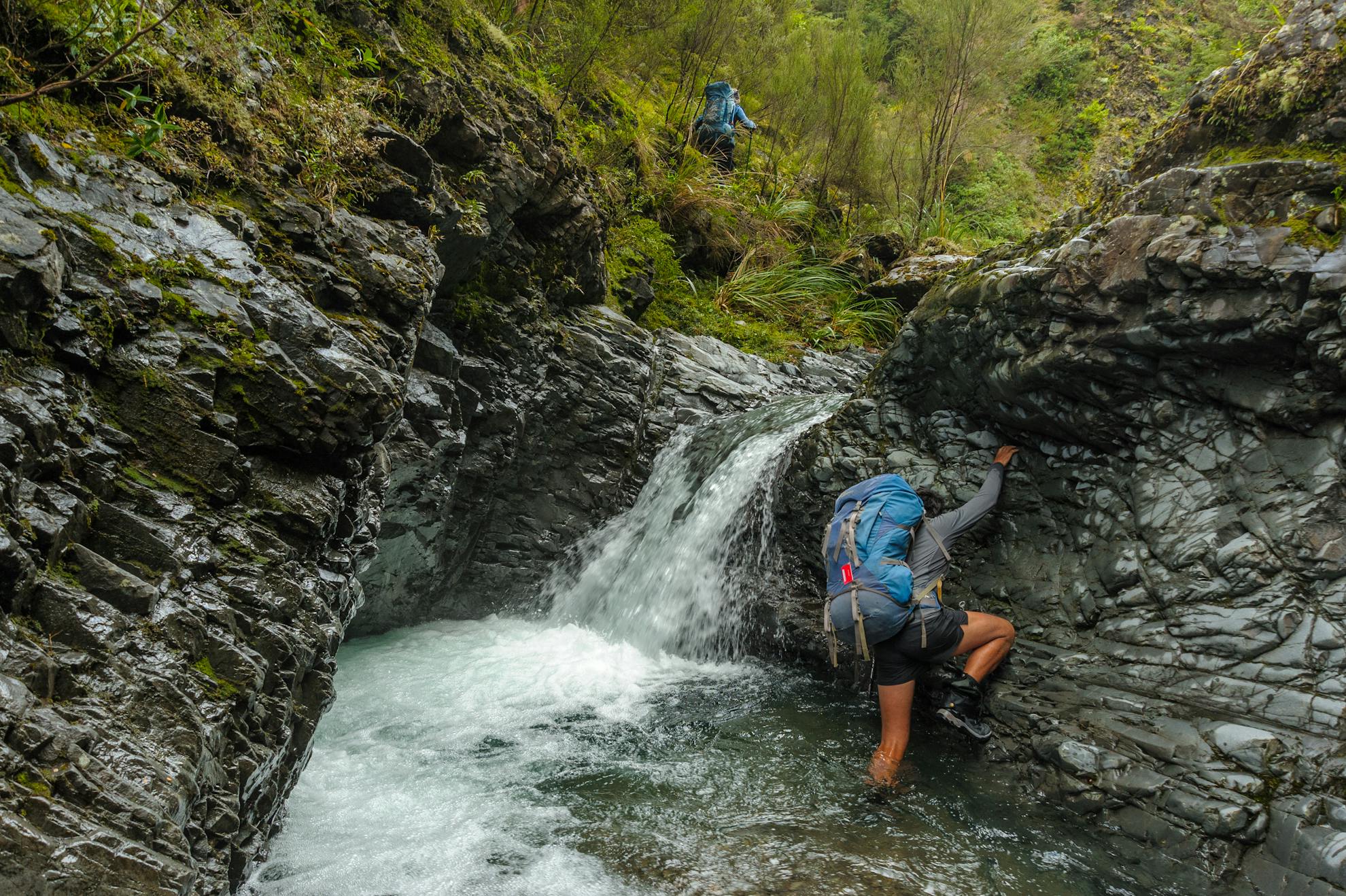
Marked by a waratah below Pt1206m, Joe knows the location of an old track, no longer maintained, but perfectly serviceable thanks to regular traffic by those who check a trap-line along it, and marked by intermittent pink tape. It pushes through wiry trees and down to the confluence of the Ikawatea River and Apias Creek, where Ikawatea Forks Hut occupies a terrace. There, we eat lunch, the dogs sniffing my salami, before shouldering packs again to tackle Apias Creek.
A stiff climb up and over a knoll avoids a gorge in the lower Apias. When we reach the creek, however, we’re in for a shock. It’s running unexpectedly high; slightly discoloured and more than unseasonably cold. The fords prove challenging in places, especially for the dogs, and my two lads get a crash course in Ruahine river travel. It’s a tight, narrow valley, with hardly any flats. The afternoon wears away, ford after cold ford. Tom is well over it by the time we reach the shelter of Rockslide Biv; his shoes filled with river gravel and his teeth chattering.
Hot food and drinks, warm clothes and dry socks restore faith that tramping can be a good experience. The dogs nestle in for some patting.
We light a crackling fire to add cheer to the autumn evening, and the orange biv takes on an eerie glow from the reflected sunset.
The following day, we leave early, still a half-day behind schedule due to our Ruahine Corner laziness. Tom, Lee and the dogs are disappointed to discover yet more river travel. But at least the water in the Apias has dwindled, the fords being shallow and gravelly. We splash up-valley, reach the major forks near the headwaters, and briefly divert to Mistake Biv. The logbook dates back to 1971.
The remainder of the day throws various challenges at us, some of them unexpected. We’d planned to keep following the Apias until one branch or another led us close to the tops. Instead, after reaching another fork, we discover a large and unmarked waterfall, the landscape sunk into bluffs and unpromisingly dense forest. It looks ugly and time-consuming.
Time to get out of the valley. Above the forks, we bush-bash on steep terrain and – leading – I run into a wasp nest. Lee is stung too; the dogs likely saved by their coats. Trudge, climb, groan, we emerge onto a scree slope and finally claw our way up to the ridge crest and – bless all DOC crews – a well-maintained track. We’re home and hosed. Well, almost; there is just the knee-jarring descent back down Golden Crown Ridge. Fluffy Floyd seems to be gathering every seed and hook grass in the range. By the end of the tramp, he’ll look like a botanist’s collection.
We all experience the world through different filters. Different things make different impressions on different people. For me, it’s been a chance to introduce my sons to the ranges that shaped my teenage years.
Later, when I asked the boys what their strongest memories of the trip were, they offered contrasting answers. Tom remembered the frigid river crossings and his frozen feet; being the leaner of the two, he’d felt the cold most. Lee recalled the wasp stings. Both had strong impressions of bush bashing; their first experience of this.
For both though, those hardships were more than tempered by the morning sunrise near Piopio and the lazy afternoon at Ruahine Corner.
Not to mention, of course, the company of Sushi and Floyd.
No doubt the dogs had an entirely different experience. For them, the tussock was well over head-height and hid all sorts of scents and information we humans are completely oblivious to.
- Distance
- 46.1km
- Total Ascent
- 3508m
- Grade
- Moderate / Difficult
- Time
- 4-5 days. Mangleton Road to Aranga Hut, 4-5hr; To Ruahine Corner Hut, 4-5hr; To Ikawatea Forks Hut, 4hr; To Rockslide Biv via Apias Creek, 3.5-4hr; To Mangleton Rd, 6-8hr
- Accom.
- Ruahine Corner Hut ($5, six bunks), Ikawatea Forks Hut ($5, seven bunks), Rockslide Biv (free, four bunks)
- Access
- Mangleton Road, Hawke’s Bay
- Map
- BK36, BK37
GPX File
- Ruahine Corner Hut (gpx, 29 KB)
GPX File
- Your device does not support GPX files. Please try a different device.
