


Lake Waikaremoana is one of two Great Walks that traverses a living entity. By Jack Austin
Lake Waikaremoana is set amidst the largest area of native forest in the North Island, right in the heart of Te Urewera, the ancestral home of Ngai Tuhoe.
Te Urewera became a legal entity with the ‘rights, powers, duties and liabilities of a legal person’ when the Te Urewera Act was passed as part of Tuhoe’s treaty settlement in 2014.
As a result, the 212,673ha park was removed from the national parks network, and from Crown ownership, and a board was formed to act on behalf of Te Urewera.
Te Urewera’s management plan is unlike any in New Zealand. Called Te Kawa o Te Urewera, it focuses on traditions, beliefs and relationships. All activities in the park are guided by values, led by the principle of what is best for Te Urewera, focused on preserving the natural features, cultural heritage and providing public use and enjoyment.
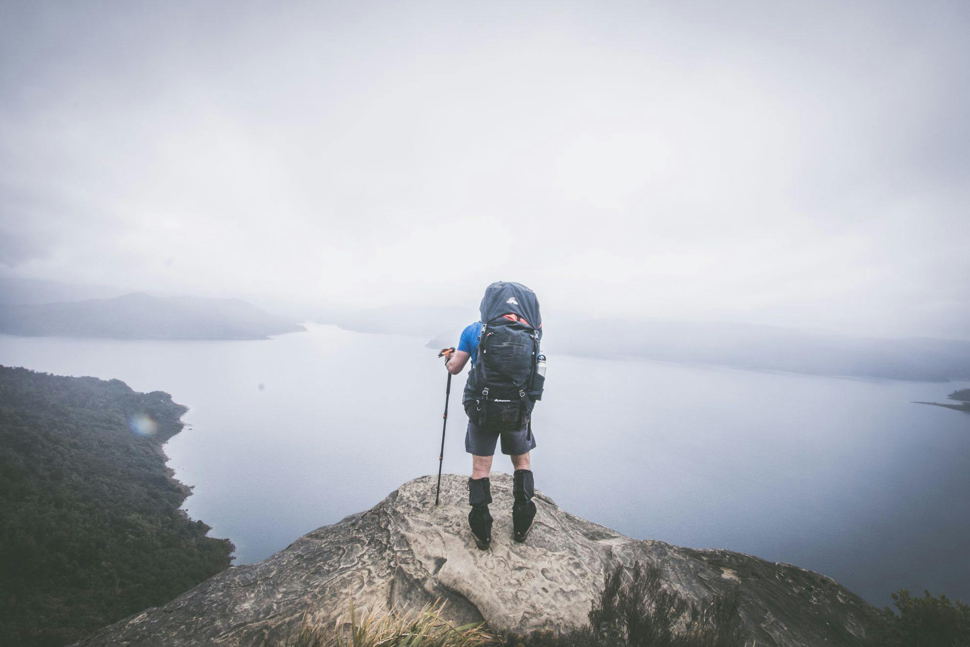
While the the region’s status has changed, the Great Walk remains the same. Over three to four days, trampers can follow the lakeshore track through ancient rainforest, past cascading waterfalls and over bluffs revealing sublime views of the great lake.
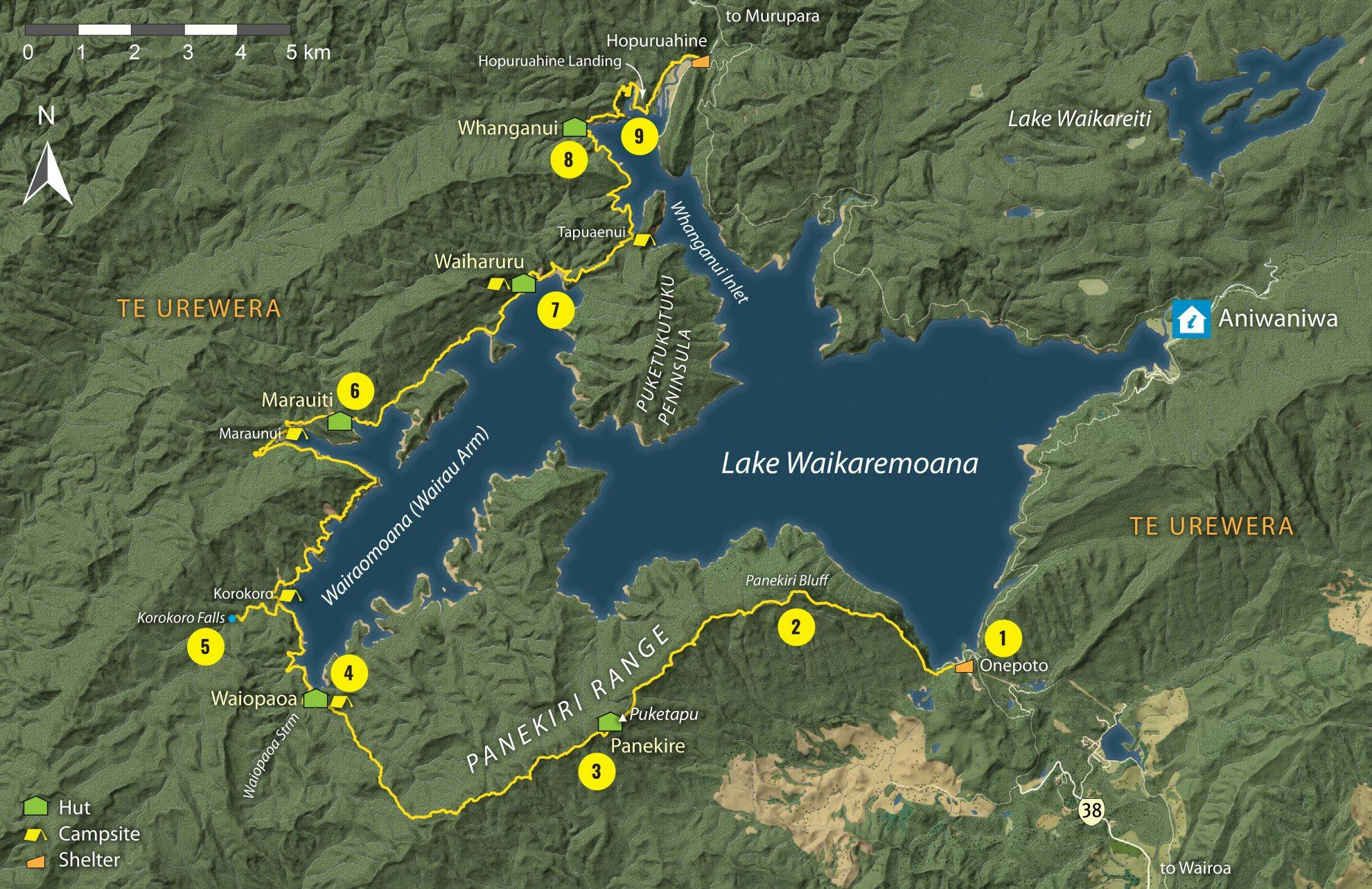
1. Onepoto Bay Landing
The start and end of this fantastic journey, Onepoto Bay Landing looks out to the far-reaching arms and bays of Lake Waikaremoana with the toughest objective of the trip, Panekire Bluffs, standing boldly behind.
2. Puketapu Trig
The track heads straight up and over Panekire Bluff, a strenuous 500m climb offering rewarding views over the lake and surrounding forest. The ridge track undulates before reaching the highest point of the walk – the 1185m Puketapu Trig – Panekire Hut is a short distance further on.
3. Panekire Hut
Panekire Hut sleeps 36 and is five hours walk from Onepoto. Placed amongst the bush atop the Panekire Bluff, views of the lake are just a short walk away via the many off-track view points. During summer, the water tank can run dry, so it pays to carry extra.
4. Waiopaoa Hut
The track is flat and easy-going for a short while before it begins a steep descent to the 30-bunk Waiopaoa Hut. The hut is tucked in amongst the surrounding beech forest and ferns of Waiopaoa Inlet and is the perfect spot to rest your legs by the lake.
5. Korokoro Falls
The 60min return side trip to these falls is a must-do. The 22m falls form an almost perfect curtain and, framed by lush native bush, are amongst the country’s most attractive.
6. Marauiti Hut
The track climbs over Whakaneke Ridge to reach Marauiti Hut (26 bunks). The hut is located on the grassy Puketuketuke Peninsula. Sit and look back to Panekire Bluff and listen out for kiwi, which are known to roam here at night.
7. Waiharuru Hut and campsite
The track follows the lakeside and then heads inland as it crosses a saddle, re-emerging at the lakeshore at Te Totara Bay. Here, you can pitch a tent right on the lake edge. The hut sleeps 40.
8. Whanganui Hut
The track climbs to a saddle between Pukehou and Pt741 and then descends to Tapuaenui Campsite. You can pitch a tent here, or carry on to the 18-bunk Whanganui Hut. Water-taxis pick-up and drop-off trampers 300m to the east of the hut.
9. Water taxi
Cruising across the lake back to Onepoto Landing provides a chance to get a sense of the scale of the environment you’ve just walked through, the huge lake and the distance covered.
Reader tip:
“The best time to visit this walk is around April. The weather is still good, but layer-up for some chilly nights! With the lack of crowds, you get a real feeling of peace and serenity. Waking early rewards the hiker with a beautiful and eerie mist rising off the lake.”
– L Johnson
When to walk
Driest period: December-January (less than 123mm of rain)
Wettest period: March-September (more than 243mm of rain)
Warmest month: February (11.6-21.3°C)
Coldest month: July (3.2- 9.3°C)
Quietest period: From May to September, numbers are less than 60 each month.
In season, December-January are busiest (748/815 walkers), while the rest of the season is less than half as busy.
Best time: February
February is the warmest and driest month, but it’s also less than half as busy as December or January,with less than 400 on the trail.
Temperature and rainfall figures are monthly averages from the Aniwaniwa and Waikaremoana weather stations. Tramper numbers from DOC data from the 2016/17 season.
- Distance
- 46km
- Total Ascent
- 2414m
- Grade
- Easy / Moderate
- Time
- 3-4 days. Onepoto Landing to Panekire Hut, 5hr; To Waiopaoa Hut and campsite, 3-4hr; To Marauiti Hut via Korokoro Falls, 5.5hr; To Waiharuru Hut and campsite, 2hr; To Whanganui Hut, 2.5hr
- Accom.
- Panekire Hut ($32, 36 bunks); Waiopaoa Hut ($32, 30 bunks); Korokoro Campsite ($14); Marauiti Hut ($32, 26 bunks); Waiharuru Hut ($32, 40 bunks); Whanganui Hut ($32, 18 bunks)
- Access
- SH38 from Rotorua
GPX File
- Lake Waikaremoana Track (gpx, 70 KB)
GPX File
- Your device does not support GPX files. Please try a different device.
