


The great Kiwi road trip is enjoying a revival in 2021. Here are five of the best routes in Aotearoa for those who like to also hit the trail.
With a fast car and a fine weekend, there is no telling the beautiful sites you could see on New Zealand roads. The same diversity which makes it the best filming location on earth also makes Aotearoa the finest for road trips. World class coastline, the serrated spine of the Southern Alps, living, breathing rainforests, volcanic deserts – it’s all there, and it’s all ‘just down the road’. Curate a playlist, buy some snacks, pack your boots and a towel, and hit the road.
1 Finding true north, Twin Coast Discovery Highway, 800km
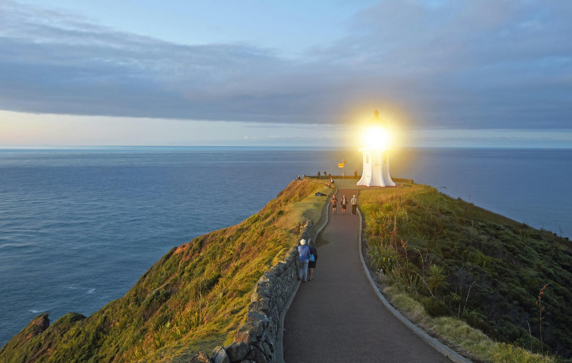
No place in Aotearoa impacts quite like Te Rerenga Wairua, Cape Reinga.
In te ao Māori, it’s the departing place of spirits who slide down the roots of an ancient and precariously-perched pohutukawa into the ocean and onwards to ancestral Hawaiiki. Regardless of your beliefs, the spot stirs your senses. Howling winds – common on the exposed fingertip of land – blow the cobwebs (and then some) from your head. In a westerly, you may hear the Pacific and Tasman meet in a running embrace, an airport reunion with a slap of spray. Salt and mānuka flowers fill the nose, and in every direction, deep blue. No matter your northern itinerary, let this be the crescendo.
The best way to get yourself there and back is well-documented, but hard to beat; the Twin Coast Discovery Highway. Like arteries and veins, State Highways 1, 10 and 12 direct tourist traffic around this well signposted Northland loop. At the northernmost junction, a detour on SH1 leads to the heart – Cape Reinga – but otherwise, there are many wonderful capillaries to explore.
‘The Loops’, as I’ve come to call them, are two worthwhile diversions on the east coast. The first, if heading north, is the Tutukaka Coast, and takes in Tutukaka, Matapouri Bay with its stunning walk to private Whale Bay, Woolleys Bay, Sandy Bay, and Daisy Bay. If you have time, a chartered boat trip to the Poor Knights Islands offers an underwater dreamland, once rated by Jacques Cousteau as amongst the world’s 10 best dives.
The second loop detours north of Kerikeri to take in tropical Matauri Bay, home of the sunken Rainbow Warrior (now a dive site), Te Ngaere Bay, Wainui Bay and Mahinepua Bay, with its stunning peninsula walk. Be sure to visit Tauranga Bay on your return to the highway – it’s well worth the detour.
The Bay of Islands is another essential stop, but don’t think you’ve seen it all at Paihia. The real magic is getting on the water and exploring the islands. Ferry services connect Paihia with the quaint seaside town of Russell and Urupukapuka Island – the largest island in the bay, and home to flourishing native birds, numerous beaches and campgrounds, a fantastic track network and – no, you’re not dreaming – a pub.
Back on the road north (if you’re not yet sick of gorgeous beaches) venture out onto Karikari Peninsula where you will find a gorgeous campsite between twin horseshoe bays of Maitai, and the blinding white sands of Puheke and Rangiputa bays.
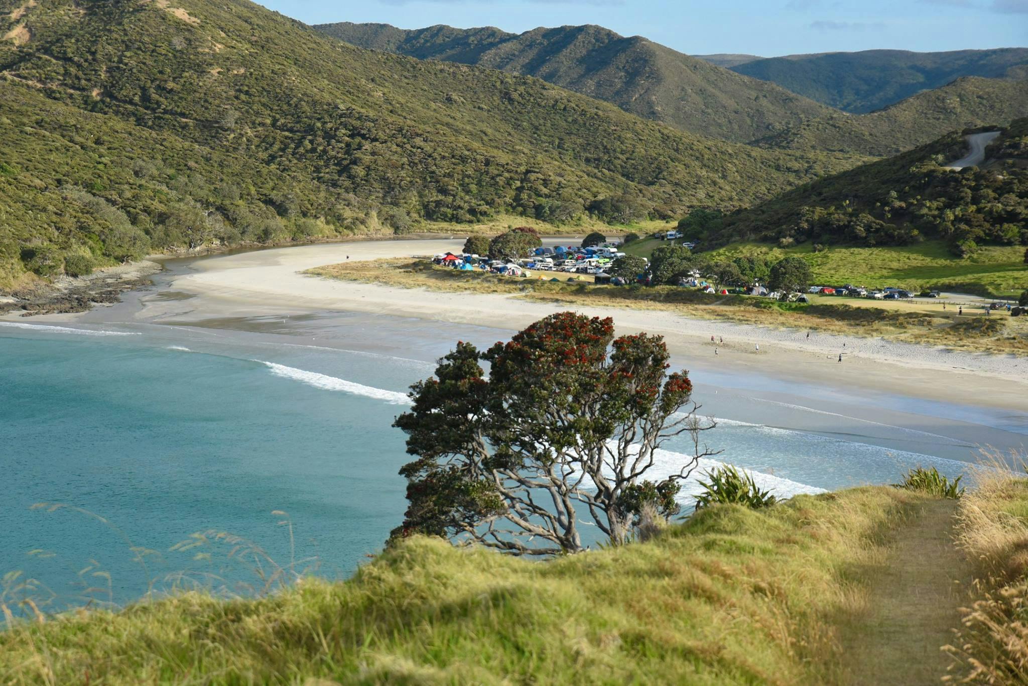
On the great northern cul de sac to Cape Reinga, there are several gems to take in en route. Rarawa Beach has sand so white and fine, it squeaks underfoot, and backlights the shallow waters a Fiji turquoise. Te Paki sand dunes are always worth a hoon, and Tapotupotu Bay offers one of Aotearoa’s finest coastal campsites, just minutes from the cape. It’s the best place to bunk down if you plan to catch the sunset or sunrise from the lighthouse. It also provides access to stunning sections of Te Paki Coastal Track, though be warned, the mosquitoes are thick as Southland sandflies. Spirits Bay, too, is stunning if you don’t mind the gravel roads.
The Auckland beach motto ‘west is best’ doesn’t translate to Northland, though there is plenty to enjoy on the more rugged return journey south. Notable beaches include the surfers’ mecca of Ahipara, Opononi, home to spectacular dunes and iconic dolphins, and the expansive and windswept Baylys Beach. If you’re sick of salt, pop in to Kai Iwi Lakes for the clearest freshwater in the region, and make sure you don’t miss the humbling taonga of Waipoua Forest, boasting Tane Mahuta, the largest remaining kauri in New Zealand.
– Matthew Cattin
2 Coast to coast, Arthur’s Pass to Lewis Pass, 672km
The double crossing of the Main Divide over Arthur’s and Lewis passes is one of the great road journeys of the Southern Hemisphere and is best completed from Arthur’s Pass via Punakaiki to Lewis Pass.
The road traverses a rich diversity of landform, climate, scenic beauty, and an encounter with the early trading routes of Māori and nation-building endeavours of the colonists. Huge braided river beds, rock gorges, peaks, passes, glaciers, rainforest and flower-filled meadows all contribute to the uniqueness of the alpine roads and a special experience for those who venture across the Divide.
From Christchurch, SH73 heads west and north over the Canterbury Plains and into the foothills at Porters Pass, 942m, beyond which are ever-changing views of the Craigieburn Range and its four ski fields, some of which have summer access for walkers, and the alpine lakes of Lyndon, Pearson and Grasmere.
There are camping options at Lake Pearson and many walking options at nearby Arthur’s Pass National Park – Hawdon Hut and Mt White could be done as an overnight trip or the ever-popular Bealey Spur, a few kilometres to the west, is a great half-day tramp.
At Arthur’s Pass Village, there are numerous accommodation options and a huge variety of walks and climbs. Aside from Devils Punchbowl Falls and Avalanche Peak, travellers could consider hiking to Temple Basin Skifield or the upper Otira Valley. For the seriously fit, there is Cons Track to Mt Cassidy.
The crossing of Arthur’s Pass is an exciting traverse, with the highlight being the spectacular viaduct and avalanche chute. Quaint Otira offers more hikes to the tops, the best being the steep bush track to Carroll Hut.
The highway sweeps down the majestic corridor of the Taramakau Valley beneath massive buttressed mountains until the coastal plain at Kumara is reached, a short hop from Greymouth. An alternative to the main highway is possible by turning off at Jacksons and taking the Lake Brunner Road through to Moana township on the north side of Lake Brunner. This beautiful lake is Westland’s largest and there are many short walks here; Rakaitane Walk at the lakeside or to the south at Iveagh Bay there’s a track to the summit of Mt Te Kinga.
To reach Greymouth take the Arnold Valley Road to Stillwater and onto the coast, but don’t miss the historic Brunner Mine site just west of Stillwater and accessed over a long swingbridge.
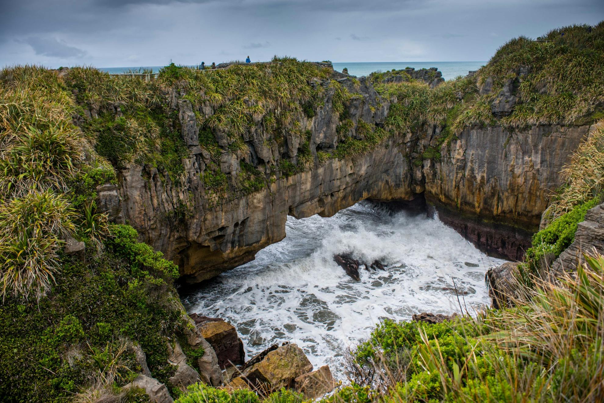
The coastal section of the route north of Greymouth is one of the most memorable sections of the journey as not only does it include Paparoa National Park and the famous Punakaiki blowholes but there are numerous stunning coastal views and short walks to experience: Coal Creek waterfall at Runanga, Point Elizabeth Walkway at Rapahoe and the Croesus Track (linking to Paparoa Great Walk) which descends to the coast at Barrytown.
At Punakaiki, there are numerous short walks like the Pororari River Trail, Truman Track, and, further north, the beautiful Fox River and the Ballroom Overhang. A minimum one night stay is recommended.
The road passes rugged beaches like those at Charleston and nearby Nile River before linking with SH6 just south of Westport.
Now it’s time to head east and south along the grand Buller River Gorge to Inangahua Junction, where SH69 heads south to historic Reefton where short walks lead to the old gold works and valley settlements, especially at Blacks Point, just to the south of the town.
The Lewis Pass Highway (SH7) is joined and, like the Arthur’s Pass section, it encompasses many grand views and accesses a plethora of tracks and short walks.
At Rahu Saddle there are moderate tracks to the tops into the upper Rahu River, or Mt Haast – very steep – or Lake Stream Hut. Over the Rahu is Springs Junction where SH7 heads onto Maruia Springs (great hot pools) passing the Lake Daniell Track, which has an overnight walk to a newly-built hut.
Lewis Pass is a wonderful viewpoint and has a large car park and picnic area just east of the summit where the St James Walkway begins (four days). A short walk here leads to a beautiful tarn while across the road a longer hike heads to the bushline on the Main Divide.
Heading south, the road passes Mt Travers Track at Deer Valley campsite, then the Nina, Doubtful, Boyle, and Hope rivers – all of which have accessible tracks and huts about 2-3hr up valley amid beautiful bush scenery.
If you hanker for more walks, or maybe missed the hot pools at Maruia Springs, you could detour to Hanmer Springs for both, and perhaps an overnight stay before driving the plains back to Christchurch.
– Pat Barrett
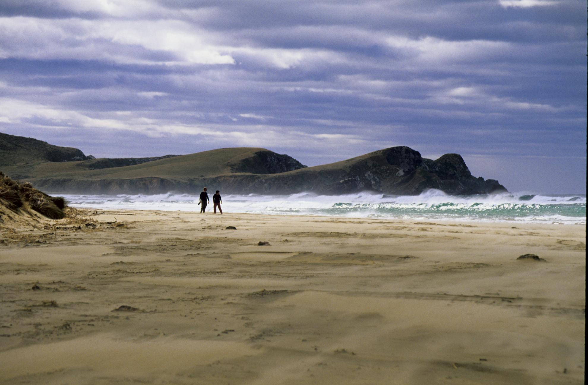
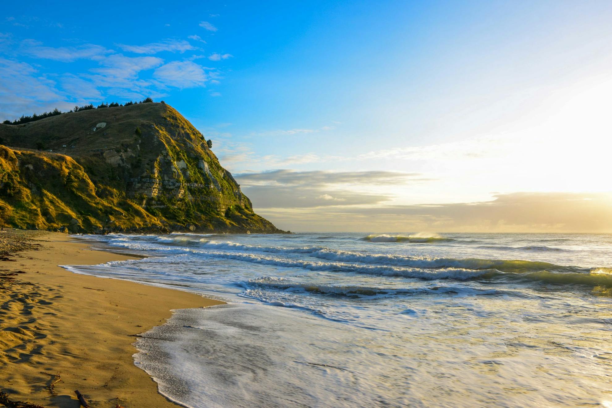
3 South Coast roadie, Dunedin to Bluff via the South Coast, 265km
This less-visited drive to the southernmost tip of the South Island is a wild and supremely beautiful introduction to a smorgasbord of natural wonders, wildlife, and history that competes for attention at virtually every curve of the highway.
With the great Southern Ocean front and centre of the car’s windscreen heading south, you are assured of wow-moments almost as soon as you leave the confines of hilltop-straddling Dunedin.
The Taieri Plain and pleasant Lake Waihola with its rolling evergreen hills and flocks of sheep are hardly preparation for the ferocious and dramatic landscape that awaits just beyond Balclutha, where the route departs from the main highway and cuts out to the coast and the granite bastion of Nugget Point and lighthouse. A short walk here goes from the car park to the lighthouse and an airy viewpoint where huge rollers smash against the sheer cliffs. Seabirds wheel overhead and seals, sea lions and even elephant seals can be spotted on the beaches below.
Owaka is next up along the road and its nearby camping domain at Pounawea is a delightful bush-backed camp with ocean views and the renowned short coastal walk to Surat and Cannibal bays where sea lions are often spotted.
Across the Catlins River estuary and up the hill is an easy stroll to Jacks Blowhole and more wild oceanscapes and then a short backtrack to the postcard-perfect Purakaunui Falls that seem to grace every booklet and brochure produced about the Catlins.
Over the hill, on Puaho Road there are more treats in store: Tahakopa and Tautuku bays and their pristine coastal podocarp forests, golden sand beaches, dune lakes, history, and wild scenery.
Amazing hardly covers what is on offer here. Like the Tahakopa Bay moa-hunters camp, Lake Wilke at Tautuku Bay and Isas Cave, where yellow-eyed penguins and little blue penguins can sometimes be seen. Inland there’s an all-day there-and-back hike up the Catlins River Track, a short walk to beautiful Matai Falls, a longer hike to Maclean Falls, the region’s highest, and a nature walk at Tautuku Lodge.
Offshore, on and around the many fearsome reefs and islands there are shipwrecks aplenty – testimony to the overwhelming power of the Southern Ocean and the storms that rage through here.
Near the MacLeans Falls turn-off, another side road heads up onto the hilltop and the steep walk down to Waipati Beach and the famed Cathedral Caves – only accessible at low tide, and a small fee is payable.
The road journeys on through more magnificent forests and farmlands to Curio Bay and its campground, ocean views, dolphins, petrified forest and wild, windy days.
But there’s more – Slope Point, the most southern place in the South Island is not far away – a more gale-stuck location would be hard to find, along with nearby Waipapa Point and the offshore wreck of the Tararua which sank in 1881 with 131 souls lost. A quicker pace now takes you on through Fortrose and around the Awarua Plains to Bluff with its viewpoint, lighthouse, and walkways.
– Pat Barrett
4 A roadie with attitude, Rotorua to Napier via Lake Waikaremoana, 502km
This long and winding road is an adventure through the mysterious heart of Te Urewera and links two of the North Island’s most beautiful cities – Rotorua and Napier.
From Rotorua, SH38 leads south past the many brooding volcanic lakes and craters and the massive and foreboding bulk of Mt Tarawera – all of which can be explored either on foot or by boat from one of the many side roads that branch off the highway. There is a plethora of excursions on offer here, and it’s worth sampling at least a few, particularly the Blue and Green lakes and the Waimangu Stream Walk to Lake Rotomahana.
The highway soon enters Kaingaroa plantation forest, the second largest in the southern hemisphere, with its arrow-straight passage through endless ranks of tall conifers before disgorging motorists at Murupara on the Rangitaiki River, at the foot of the vast and ancient forests of Te Urewera.
The highway winds through the steep forested hills, passing over high ridges and streamlets into the Whirinaki Valley and the village of Te Whaiti. Minginui is just a little farther south of the main road and from here there are numerous tracks and trails into the bush.
However, SH38 carries on through the forest, passing tiny villages, wild horses along the roadside and abandoned buildings and vehicles, before reaching Ruatahuna on the Whakatane River. The most challenging part of the journey begins here, where SH38 ends and the narrow, twisting conduit of Waikaremoana Road penetrates the forest once more to climb to Taupeupe Saddle, 923m, and finally arrive at Lake Waikaremoana and the spectacular view of Waihere Bluff.
A couple of days can be spent here to walk some of the numerous forest trails to outlying lakes, waterfalls and viewpoints, like Panekeri Bluff, Lake Waikareti or Ngamoko Track. From Waikaremoana, SH38 begins again and traverses the rural landscape of the Waikaretaheke Valley all the way to Wairoa in Hawke’s Bay. If time allows, Te Reinga Falls, 35m, on the Wairoa River, a short drive from Wairoa, makes for an excellent short walk. For a full day trip, head along the coastal highway to Mahia Peninsula and its spectacular oceanscapes.
From Wairoa, SH2 skirts the coast and heads inland through a varied rural and sometimes forested landscape to Napier with the Kaweka and Ruahine ranges right on its doorstep. For a final overnight stay beyond the towns and cities, consider taking Tangoio Settlement Road, just north of Napier, into the secluded setting of Waipatiki Beach and camp, and its superb coastal walkway.
– Pat Barrett
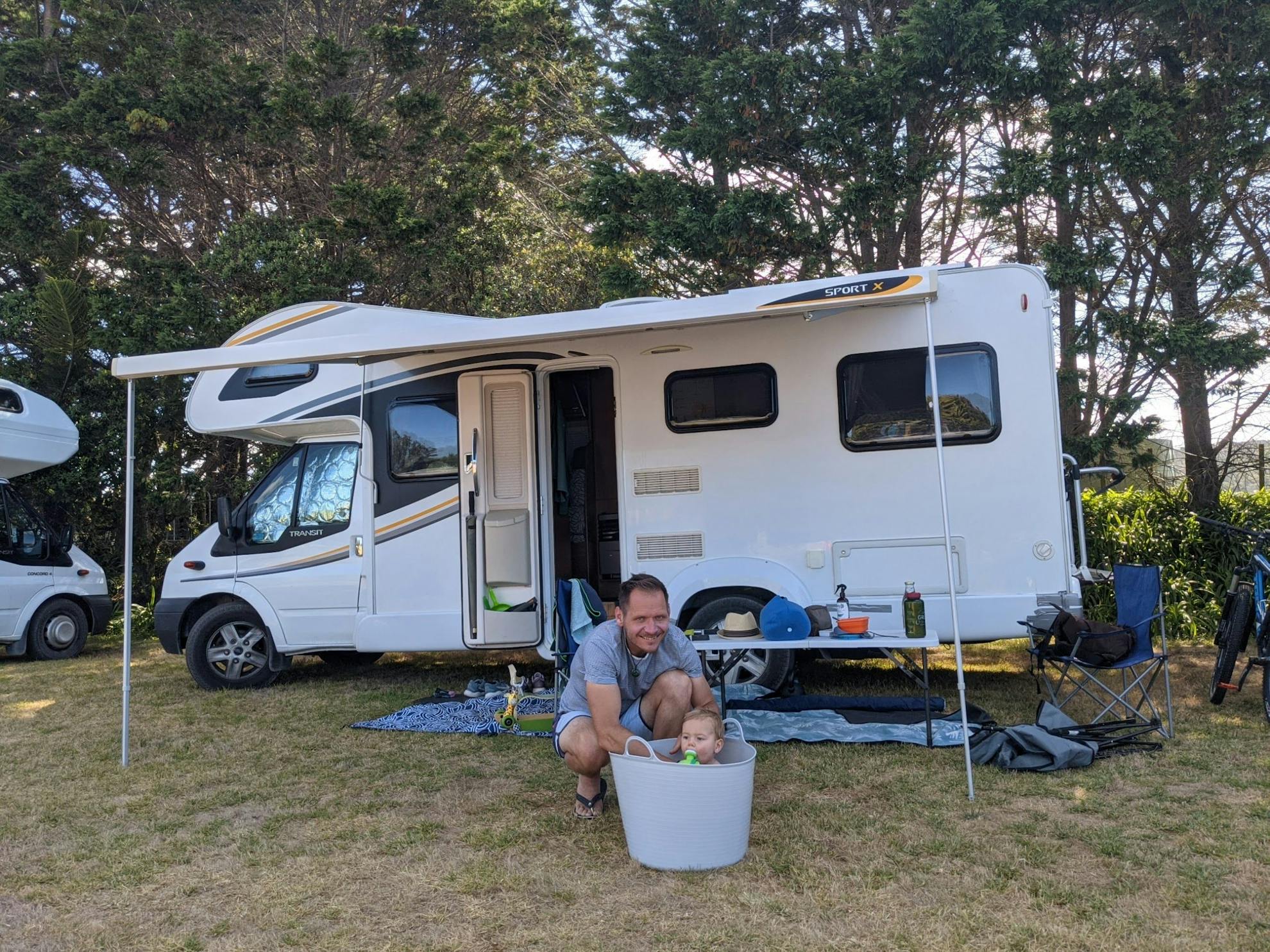
How to do a road trip with a toddler
Any road trip with a toddler can be difficult, but with some careful planning, it’s not impossible. Judit Angeli, who is driving around New Zealand with her 10-month-old, offers some tips.
All parents know what happens when their baby’s routine is messed up. It’s bound to happen at some point on a road trip, but there is a great deal that can be done to keep the peace and create lasting memories together.
Baby is boss: It pays to work around wake-ups, daytime sleeps and feeding schedules. Exactly the same as at home, just on the go.
Create a baby-friendly space: We have utilised the lounge space at the back of our motorhome to double as a playpen and is also home to the travel cot. We added a curtain that can be pulled across at nap times and usually use a white noise machine to block out any background sounds that could easily wake baby up.
All-weather set-up: Have a system that works well for you and your baby on sunny days, as well as when the weather turns and you are stuck inside. A portable high chair can clip onto the motorhome’s indoor table and to almost any table or park bench for roadside or campsite dinners. We try to save on campsite fees by staying at freedom campsites where there is no kitchen or other facilities, so planning meals in advance is a must and an outdoor cooking equipment allows meals to be prepared while the baby is asleep.
Limit driving distances: Plan frequent stops where everyone can have fun, even if it means doing a few longer drives when the baby is asleep. It pays to sneak in some good activities each time, so the driving doesn’t get overwhelming for anyone.
Baby monitor: A long-range baby monitor has allowed us some much-needed time for ourselves that we wouldn’t have been able to otherwise get, including lunchtime ocean swims, relaxing in a campsite spa pool, dinner with fellow campers and even the weekly shopping.
Use the facilities: Public libraries have toddler corners, baby play spaces and free toddler sessions. Seek out the child-friendly camping spots. Every town has free baby-friendly activities to participate in.
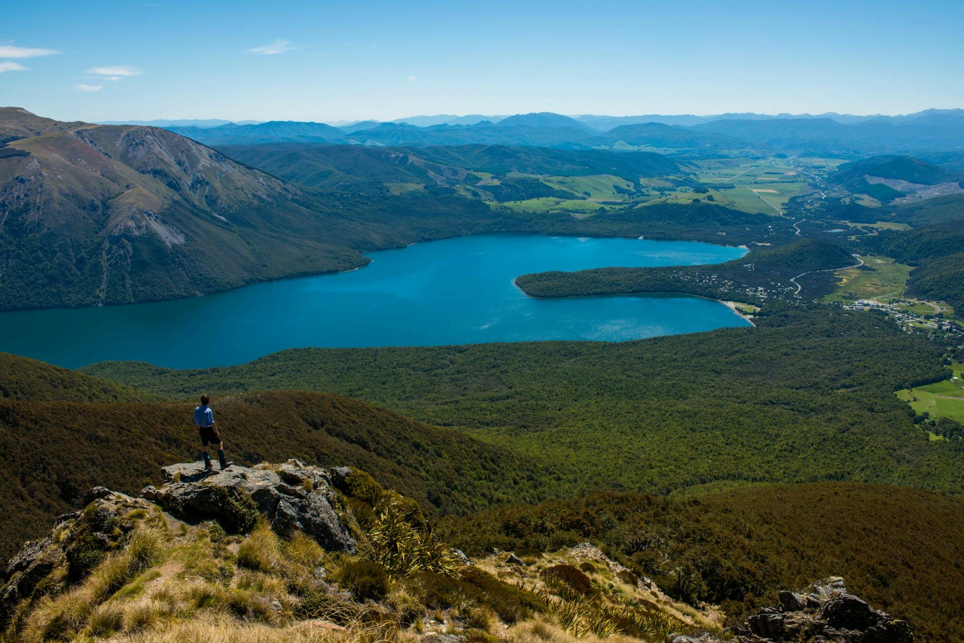
5 Mountains of Sounds, Picton to Picton via St Arnaud, 276km
A round trip roadie over a short distance, the Picton to Picton route via Wairau Valley to St Arnaud and back via Queen Charlotte Drive, is an undiscovered gem at the northernmost corner of the South Island. It’s a trip that encompasses grand scenery, mountain lakes, rainforest, and the scenic wonders of the Marlborough Sounds.
From Picton, travellers first ply the heavily trafficked SH1 to picturesque Blenheim and its renowned vineyards before heading west and south through Renwick and along SH63 through the magnificent Wairau Valley.
This almost arrow-straight highway sits astride the Great Alpine Fault which exits the South Island through the Wairau after having traversed the entire South Island. Both sides of the valley are furnished with tall mountain ranges – the Richmond Range to the north and the Raglan Range to the south. The Richmonds provide unrivalled tramping options and can be accessed along the Northbank Road from Renwick, while the Raglan Range can be accessed on the Branch River and from the Wairau Hanmer Springs Hydro Road just east of St Arnaud. Red Hills Hut, accessed near this road junction, makes for an enjoyable overnight trip.
St Arnaud is a quaint village nestled around the shores of Lake Rotoiti in Nelson Lakes National Park. There are camping and various accommodation options here and the chance to savour the views of lake and mountain from one of the many walks that begin at the lakeside, or you could take a boat to the lake head and walk back.
St Arnaud deserves at least a night or two to make the most of all the walking, boating, and fishing options.
Lake Rotoiti is the source of the Buller River and it is this that the road now follows through to Kawatiri Junction and then over Hope Saddle on SH6 to Kohatu in the Motueka Valley. Although the road carries on to Wakefield and Nelson from here, a side trip could be made down the scenic Motueka Highway which leads to parts of Kahurangi National Park. Check out the Baton and Pearse rivers and the ever-popular Flora Saddle and Mt Arthur.
At Nelson, the western side of the Richmond Range is an easier option; the beautiful Cable Bay Walkway is just out of town.
The road winds through the northern end of the Bryant Range and over Rai Saddle to lovely Rai Valley and the superb Pelorus Bridge swimming holes and campground. On a fine day, with a low river, the emerald green pools are irresistible.
The penultimate part of the journey continues down the Pelorus Valley to the head of Pelorus Sound at the delightful little town of Havelock. With just 33km to Picton, via Queen Charlotte Drive, there’s a temptation to rush this section, yet this part of the road trip is one of the most memorable. From its headland viewpoints of the Sounds to quiet rural landscapes, the Queen Charlotte Walkway and Anakiwa, to the hidden ghost town and gold mining sites at Cullensville, there is endless opportunity to explore a wonderful part of New Zealand.
– Pat Barrett
