


The Milford Track is the original ‘great’ walk and the one that put Kiwi tramping on the international map.
At just over 53km in length, the world-famous Milford Track is liberally endowed with some of the most spectacular natural sights of any track in New Zealand and, indeed, the world.
From its very beginning at the mouth of the Clinton River, the Milford Track leads trampers ever deeper into the Fiordland wilds, enfolding them in a deep green symphony of river, valley, forest, and mountain top where waterfalls erupt from every crevice, granite faces soar skywards at impossible angles and emerald pools shimmer from the rivers.
This is a place to savour, and given the track can only be walked in one direction during the season and the number walking it each day is strictly limited, you can guarantee there will be an extraordinary encounter with nature in a unique part of the globe.
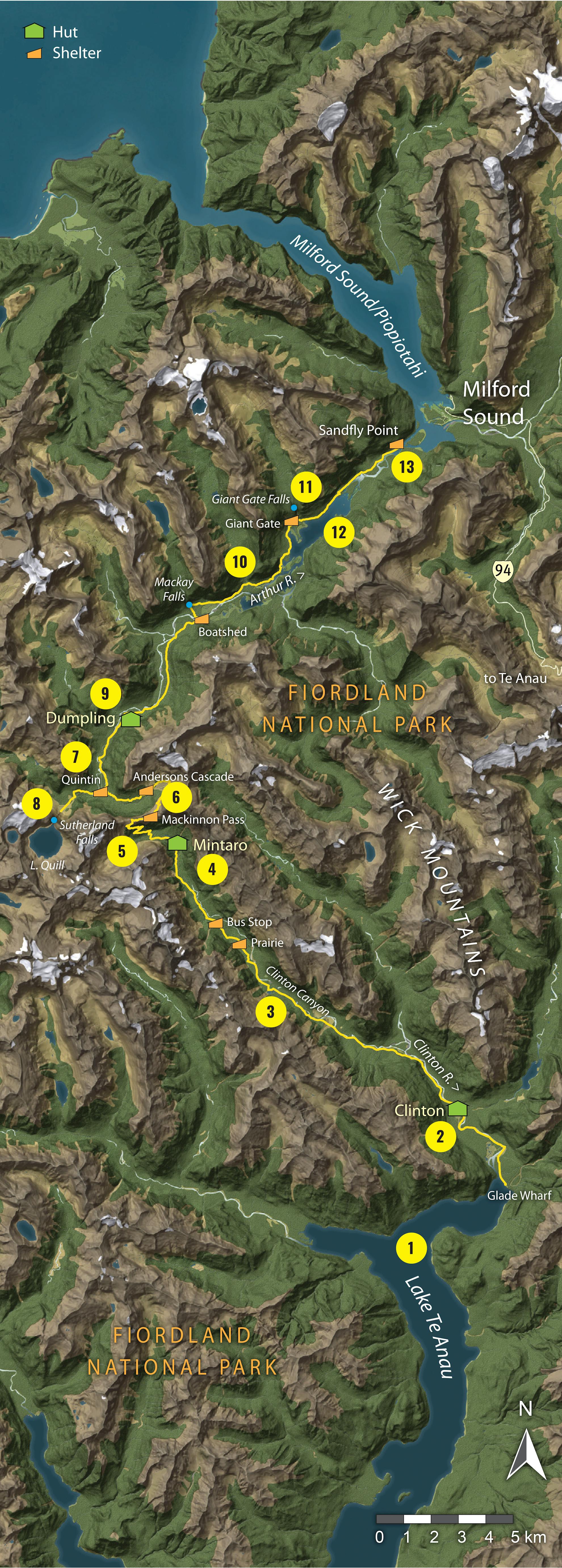
1. Lake Te Anau
New Zealand’s second largest lake is the gateway to the Milford Track, where ferries leave daily, during the season, from Te Anau Downs to begin the beautiful cruise to Glade Wharf at the lake head. Here, the impressive ramparts of the mountain fastnesses dip into the lake depths.
2. Clinton Hut and river
The most beautiful river on the track, the Clinton is a renowned fishing river and has a delightfully easy path leading to the 40-bunk Clinton Hut, just two hours from the wharf.
3. Clinton Canyon
The upper Clinton River is a wild and dramatic place where the valley climbs steadily through the unfolding majesty of the Clinton Canyon – a defile of rock and precipice lorded over by 2000m summits and split by fissures where waterfalls tumble.
4. Mintaro Hut
Sited in the forest in the upper valley at 600m, directly below MacKinnon Pass, Mintaro Hut is a full day’s walk from Clinton Hut and is the staging point for tackling the pass. Lake Mintaro is nearby.
Reader Tip:
“Don’t forget to take a notebook
with you to write
down all the useful information given
by the ranger at the first hut.”
– M Prescott
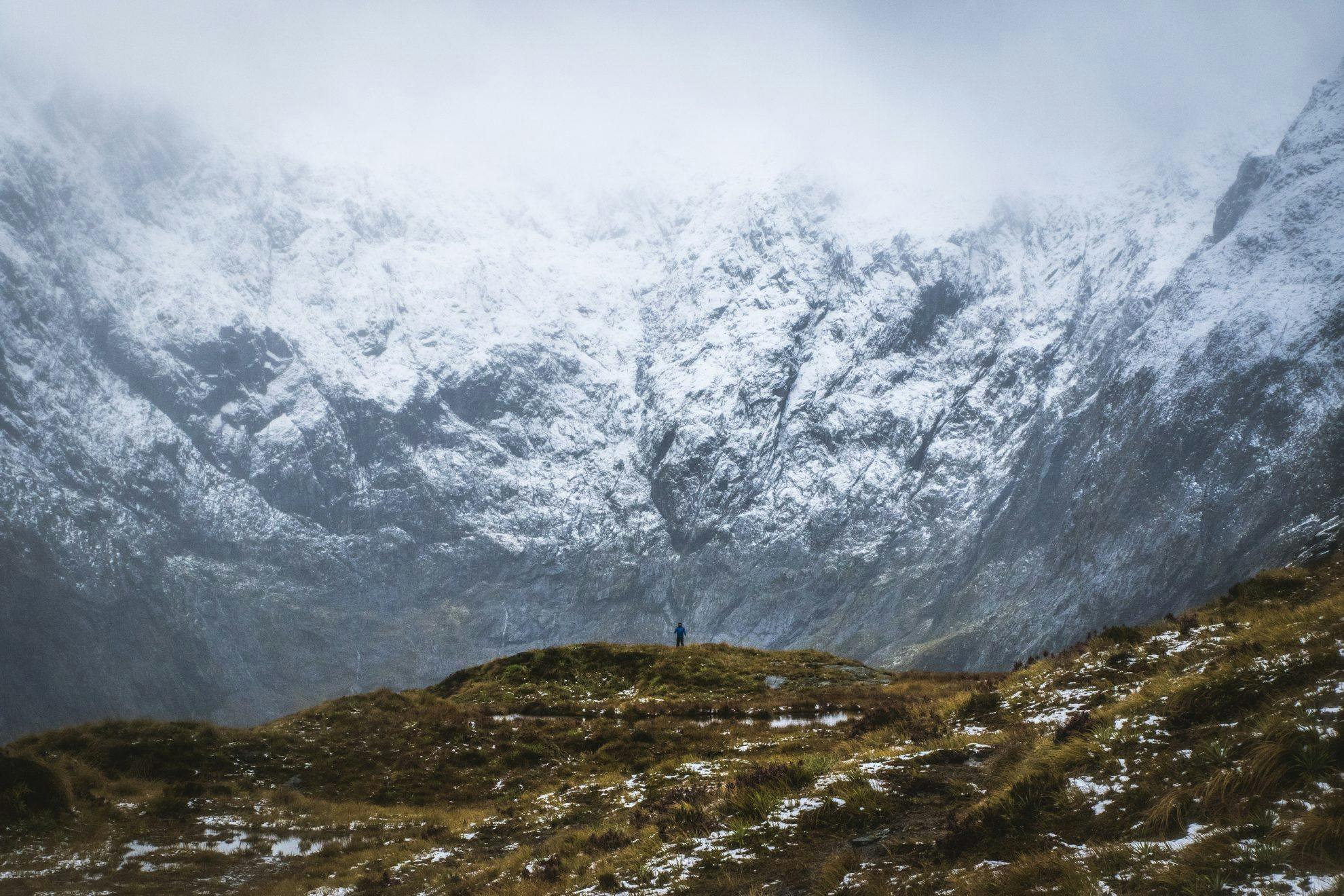
5. Mackinnon Pass
Discovered in 1888 by Quintin Mackinnon, this broad sweep of the Main Divide has granted safe passage to Milford Sound for generations of adventurers. The climb to the stunning pass on the steep zig-zag trail from Mintaro Hut will be the hardest day of of the walk for most.
6. Roaring Burn
This is the route to the lower Arthur Valley, passing beneath the flanks of Mt Balloon and Mt Elliot which during winter and spring regularly send large airborne avalanches over their precipitous slopes and into the valley. A direct short-cut ’emergency track’ is available to avoid this danger during spring.
7. Quintin Shelter
Sited in the upper Arthur Valley, Quintin Shelter is a welcome sight for those traversing MacKinnon Pass, especially in foul weather, and offers refuge for those wanting to enjoy the overwhelming grandeur of the valley. Mt Hart, directly to the south, presents a particularly spectacular 1000m face of rock and forest.
8. Sutherland Falls
One of New Zealand’s highest waterfalls, Sutherland Falls (580m) drain Lake Quill, a large alpine lake at 980m, and reach the valley floor not far from Quintin Shelter. The 90-minute return trip to the falls is one of the highlights of the track.
9. Dumpling Hut
The final hut of the walk, reached in 6-7hr from Mintaro Hut.
10. Arthur Valley
The Arthur Valley is at a much lower altitude than the Clinton, more heavily bush-covered and subject to sudden flooding.
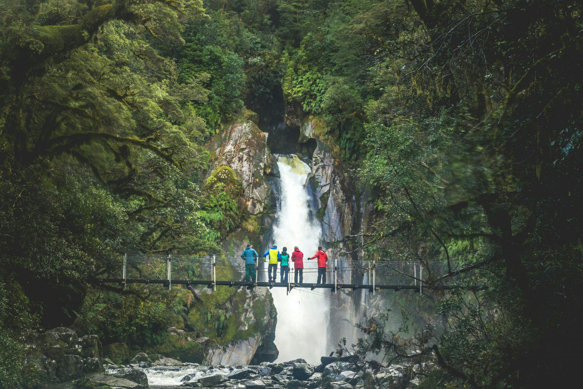
11. Giant Gate Falls
After Sutherland Falls, the Giant Gate Falls, in the lower Arthur, present a memorable spectacle viewed from the swingbridge which spans the downstream flow. The falls are a powerful barrier guarding access to a sizeable unnamed catchment beneath the Llawrenny Peaks.
12. Lake Ada
This large, swampy lake in the lower Arthur Valley was once a natural barrier to access, particularly in times of heavy rain when a boat was essential to reach the upper valley. Now a track cut and blasted into the mountainside above the lakeshore providesall-weather passage.
13. Sandfly Point
Sandfly Point marks the end of the track. From here, access is only by boat, and yes, the sandflies are intolerable!
When to walk
Driest period: June-August (less than 487mm of rain)
Wettest period: December-January (more than 700mm of rain)
Warmest month: February (10.3-19.3°C)
Coldest month: July (1.3- 9.2°C)
Quietest period: The Milford Track is booked out throughout the season.
Best time: February
The busiest and wettest Great Walk, the best time to walk it is whenever you are able to book a bunk. But February in Milford Sound has nearly half the rainfall of January, so you’re more likely to get clearer views – although if waterfalls are more your thing, December and January would be the time to go.
Temperature and rainfall figures are monthly averages from the Milford Sound weather station. Temperatures on the alpine section are likely to be significantly colder. Tramper numbers from DOC data from the 2016/17 season.
- Distance
- 53km
- Total Ascent
- 2201m
- Grade
- Moderate
- Time
- our days. Glade Wharf to Clinton Hut, 1-2hr; To Mintaro Hut, 6hr; To Dumpling Hut, 6-7hr; To Sandfly Point, 5-6hr
- Accom.
- Clinton Hut (40 bunks), Mintaro Hut (40 bunks), Dumpling Hut (40 bunks)
- Access
- By boat from Te Anau Downs
GPX File
- Milford Track (gpx, 32 KB)
GPX File
- Your device does not support GPX files. Please try a different device.
