


Mark Watson combines The Old Ghost Road with an old school classic for a 173km loop taking in the best of West Coast mountain biking
With a bowl of muesli in one hand and the other sweeping sandflies from my field of view, I survey the terraces and rolling green grass, encroached by scrub that surrounds us.
I try to imagine Lyell: the town of more than 2000 people that was once here and the services that might have lined the streets: the hotels, banks, post office, ironmongers, grocers and stables. I can see the mud, the puddles, men stooped under loads and women in billowy skirts. Coal smoke weighs the air. I can hear horses and carts, mechanical clanking and the sound of wood splitting. The sounds of the richest gold town in the Buller District.
An intense buzzing snaps me from my ruminations and I lose the food from my spoon. Sandflies.
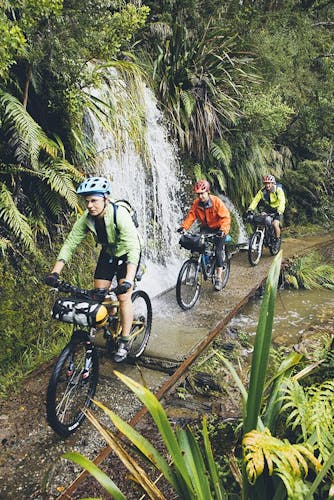
We mount up: with pedals clicking, bums settling into saddles, and freewheeling down and across the bridge. The beech forest swallows us, the sandflies left behind. It’s 9am, but already the bush is hot and humming. Summer on the West Coast. I’m fit, but the bike feels heavy with overnight gear decorating my frame and I work the gears to maintain cadence on the climb. Sweat glazes my forearms and a trickle tickles my temple. Beech leaves crunch like cornflakes beneath our tyres.
The climb is gentle, but steady, following an easy grade through the contours. It’s a grade favoured by the gold miners who worked these hills during the gold rush of the 1860s.
A glance at the map reveals that we’re passing Gibbstown, Zalatown and Eight Mile – communities that once clustered in the bush here, toiling. Trackside objects tell their story and punctuate the steady tempo of our climb: a rail bogie, a boot sole, a rusting shovel. This place is an outdoor museum.
Maori were the first to find gold in the Lyell region but it took the bountiful discoveries of European prospectors to foster the gold rush that followed. In the boom-and-bust fashion typical of the gold years, Lyell and satellite settlements developed and flourished over a 30-year period before waning in the face of diminishing finds. The region’s main mine closed in 1906. A declining population and a series of fires saw the eventual abandonment of the town.
The ancient pack track winds its way in and out of gullies and around spurs, the bush breaking occasionally to allow peeks into the valley. A steep scree slide forces a dismount and provides a view to the tops, across the folded, forested valleys. We ride on, arriving at Lyell Saddle hungry, sweaty and in need of a break. This is the site of the first hut built for The Old Ghost Road and makes a great spot for lunch. The bush has shrunk now and the amorphous, gnarled trunks of beech trees surround us. Wispy lichen drapes the branches; its soft movement revealing the breeze.
We climb onwards on an improved tramping track. This section, like others we’ll ride later, is a work in progress and I’m working harder to pick a line, keep traction and avoid the biggest stones. The bush thins and as we break onto the tops, Lyell Saddle lies far below, it’s beech canopy smoothed by the prevailing wind.
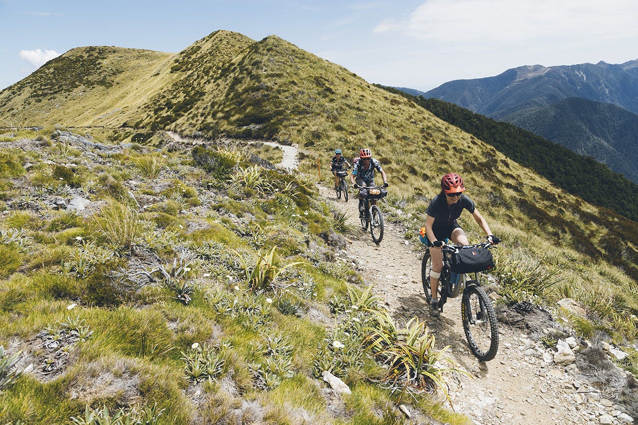
The tops are a whole new world; alpine plants replace the tone of the beech forest, rocky massifs stand above us and across the ranges other peaks seem to float above the bushline, like ships on the high seas. The humidity of the bush is replaced with a warm afternoon wind, and we move more quickly along the range; the climbing’s mostly over for the day and we enjoy the speed.
The perfectly sited Ghost Lake Hut and Rocky Tor. Photo: Mark Watson
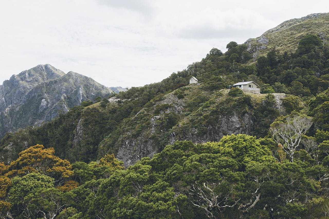
Beneath Rocky Tor, the track sidles across a steep face. The riding’s fun and never technical, but it is exposed. We pass the distinctive Tombstone boulder and eventually the track drops towards the bushline again, emerging at Ghost Lake Hut – our stopping point for the night.
The hut’s well-sited; perched on the edge of a cliff, overlooking its namesake tarn and with expansive views to the Thousand Acre Plateau. We’ve booked one of three outlier mini huts that serve as separate accommodation rooms – perfect for escaping the snorers. The deck at the main hut makes a perfect spot for New Year’s Day cocktails and we sip and savour the evening sun and lack of sandflies this elevation brings.
Borne from considerable volunteer effort and managed under the umbrella of the Mokihinui-Lyell Backcountry Trust, the possibility for The Old Ghost Road as a recreation through-route was recognised in 2007, when a copy of the original 1886 reconnaissance survey found its way into the hands of Seddonville local Marion Boatwright, owner of the Rough and Tumble Bush Lodge. The map showed a surveyed route through rugged country linking established and well-travelled sections of a gold miner’s dray trail at Lyell and Mokihinui. The route between the two had previously been the domain of trampers prepared for unmarked travel along the tops and backcountry route-finding.
Boatwright recruited a team to assist in realising the dream of linking the trail, and the project gained enough momentum to encourage significant grants, government recognition and a large volunteer contribution.
Over the intervening years, rumours, controversy and excitement surrounded the trail as four huts and 16 bridges were built and interpretive panels installed. The genius of this trail, totalling 85km and with more than 2600m total ascent gain, is that it has been crafted to utilise the terrain that it covers expertly. It ‘flows’ and provides the best possible physical experience of riding the trail. Experienced trail builders were involved to achieve this, and also to ensure it would drain well to cope with the West Coast’s significant rainfall. Climbing grades are kept reasonable, and where the trail heads downhill, its passage navigates terrain that makes mountain bikers hoot with delight.
Riding the historic Charming Creek Walkway, an old mining rail route. Photo: Mark Watson
We wake to steady rain and depart the hut, resigned to what will probably be a long wet day. There’s no real warm-up; from the hut the trail descends a series of switchbacks that tests the balance of the best riders. The crushed granite trail surface makes traction unpredictable and the trajectory uncertain. It’s a good challenge, but soon the trail mellows and enters a beautiful section of montane forest, before climbing to an open granite knoll and then winding its way along and down a photogenic section of exposed ridge. Either side, the slope falls away to the bush below, but our concentration is forward: milking the width of trail, weaving around rocks, to keep flow in the corners.
Our downward progress comes to an abrupt halt at the top of the Skyline Steps – installed to allow passage down a very steep section. We dismount and carry our bikes.
We’re soon pedalling again, while the rain steadily falls. Down we go, winding along a perfectly built trail, turning this way and that, carving around the corners and descending steadily while the forest slowly grows taller.
Just as we’re getting used to the terrain, it changes again. The landscape is full of surprises. In the Earnest Valley section great boulders litter the slopes and flats, and the floor of the valley has been reshaped by landslides, flooding and infill.
We weave around the spartan rocky valley and depart by a steady climb to Solemn Saddle.
Specimen Point is the next cool thing we see. A perfectly-sited hut here takes in a magnificent view of the bouldery Mokihinui River, running large after the steady rain, and the steep bush-covered hills that seem to climb endlessly into the mist. Before too long we pick up the northern section of the historic miner’s track and the riding’s fast as we sidle the edge of the river gorge. The trail undulates through bush thick with supplejack and punga – alive with the sound of small streams. Water’s everywhere.
While most people end their ride at Seddonville, we’re only halfway through our planned loop when we emerge from the bush next to the Rough and Tumble Lodge. A few kilometres down the road takes us to the Seddonville Hotel where we eat and overnight. Next day, we’re headed for the Denniston Plateau to ride the Denniston Shortcut and complete a full loop back to the cars at Lyell.
The Charming Creek Walkway makes a convenient and scenic alternative route out to the coast and after heavy overnight rain, the river is a spectacular sight roaring down the gorge in full flood. Waterfalls pour from the cliffs and surround us with spray. The walkway features many relics remaining from mining days and, despite the rain, makes a great outing.
Our route through the Denniston high country crosses the Mackley River, a significant watercourse with a reputation for high water after rain, so we take an overnight stop on the coast, with clearing skies, before heading up the long sealed-road climb to Denniston the following morning in hope of finding the Mackley crossable. With the 7km climb behind us, we cross the remarkable Denniston Plateau. Coal mining remnants dot this stark, scrubby landscape – a location that is in bold contrast to the lush rainforest and beech of the previous days.
We reach the edge of the plateau via a 4WD road that continues right through to Lyell; though you couldn’t tell: ridge after ridge of bush-covered ranges roll away from our vantage point, but the tell-tale high voltage pylons, marching across the remote landscape, hint that there might be a road down there, somewhere.
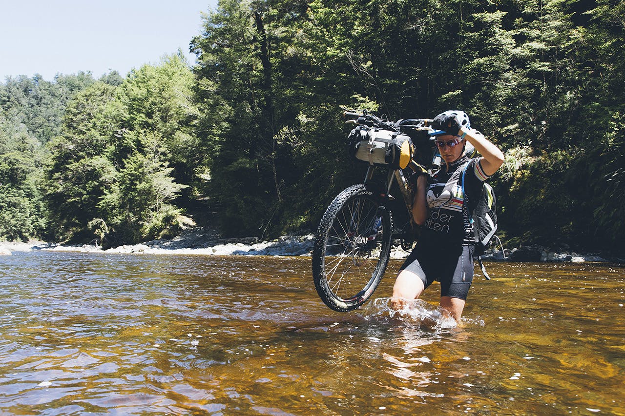
Wading the Mackey River. Photo: Mark Watson
After the purpose-built singletrack of the Old Ghost Road, the rocky and rutted road is a different style of riding entirely and reminds me of mountain biking in the 1990s, when I’d search topo maps for obscure 4WD tracks. They were the days of crashes, double snake bite punctures and dented rims. Bikes are better now, with full suspension, tubeless tyres and decent brakes. With this technology, the road is more fun and we tear down the rocky track, stones pinging off our bike frames, milking the berms formed on the road edge by quad bikes.
It’s an afternoon of constant up and down in the summer heat; steep climbs followed by winding descents. The Mackley’s at a safe level and we cross the thigh-deep stony river bed, carrying our bikes, and tackle another granny-gear climb before finally emerging at the Buller Gorge.
It’s a tough ride, but with that comes the satisfaction of a self-powered journey through remote country.
Breaking into beer and chips at the Lyell car park, we’re stoked to have completed a classic loop of varied riding through some stunning West Coast country.
