


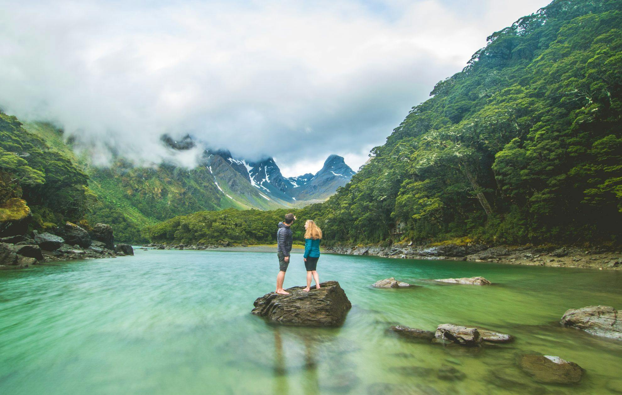

Two national parks, two iconic valleys, and more stunning views, lakes and waterfalls than you can point a selfie-stick at – the Routeburn is the complete package.
It’s hard to beat the Routeburn on a good day. There is a world of rainforest green – mosses, lichens and orchids. Kaka and kea inhabit these parts. Stunning lakes are
towered over by glacier-studded granite mountains with waterfalls cascading over track-side bluffs.
But the track is also exposed along the Hollyford Bluffs and can make trampers feel alive in a good Fiordland storm. Be prepared for four seasons in one day and to weather some of the hardships experienced by the early explorers.
The track can be walked from either end. Starting at The Divide, it climbs through a rainforest to Lake Howden Hut and then on to Lake Mackenzie Hut, in the shadow of the finger-like Emily Peak. The Hollyford Bluffs provide a view all the way to the Tasman, before traversing Harris Saddle (and a detour to Conical Hill) to the Routeburn side and the Routeburn Falls. Descending through beech forest toward the head of Lake Wakatipu is a marked difference, encapsulating the variety of terrain and scenery the Routeburn Track offers.
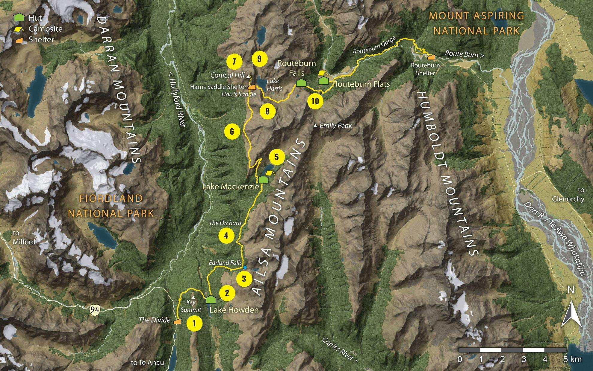
1. Key Summit
Few places summon such vast and enthralling views as Key Summit. To the north is the Hollyford Valley, flanked by the Ailsa and Darran mountains. Above the Lake Marian bowl is Mt Christina and serrated Mt Crosscut. East is the Greenstone Valley, with the Eglinton sneaking into the south. The European name of Key Summit refers to the fact it is the ‘key’ to three watersheds. A drop of rain falling on Key Summit can end up in the Southern Ocean, Tasman Sea or the Pacific.
2. Lake Howden
At the junction with the track to Howden Hut, the trail descends through silver beech forest with the trees smothered in moss. The rippling stream emanating from Lake Howden is a soothing accompaniment to observing black swans foraging in the cool waters, while red-fronted parakeets and tui enliven the forest rim.
3. Earland Falls
The 174m-high falls spread on their descent, sending bursts of spray in all directions. Take care as the surfaces are slippery. The streams emptying the plunge pool weave around rocks – to get a good photo, you need to crouch in the lee of the spray and poke your camera up. Shortly after is a clearing caused by a landslip which offers the first extensive view of the Darran Mountains, with all the major peaks in sight.
4. The Orchard
On the way to Lake Mackenzie is The Orchard. Aptly named, this clearing is filled with ribbonwood trees which could be mistaken for a Somerset apple orchard. The first views of Lake McKerrow open up at the head of the Hollyford Valley with the spurs of the Skippers Range receding into the distance.
5. Lake Mackenzie
The rocks scattered at the base of the lake are often joined by trampers lying strewn asleep on the grass. Submerged rocks beneath the green waters lead to the spectacular Ocean and Emily peaks. It’s an excellent spot for a quick dip.
Reader Tip:
“Add as much time into your trip as possible
and do the side trips – it’s best to make it a four day trip.
Key Summit, Conical Hill and Lake Wilson are musts.
And don’t forget to visit the North Route Burn, which is
more untamed than the beautiful but
busy Route Burn Valley.”
– Robbie Ings
6. Hollyford Bluffs
Orange waratahs mark the zigzags up the face. At the apex of the spur is a view stretching from the Earl Mountains 50km to the coast at Martins Bay. It includes the impressive glacier-clad Darran Mountains.The section along the Hollyford Bluffs is open and exposed, far above the treeline. If you catch this section on a bad day, the journey to Routeburn Falls Hut will be arduous, and at times you’ll be thankful for the orange marker poles.
7. Conical Hill
In a tramp filled with views, this is the viewpoint of the track. It’s a 260m climb to the summit of the oddly-shaped hill, a smoothed rock at the southernmost end of the Serpentine Range. From the summit, tick off the Darran peaks, including Mts Christina, Crosscut, Te Wera, Madeline and Tutoko – Fiordland’s highest at 2723m.
8. Lake Harris
The track sidles the bowl above Lake Harris through a strange terrain of hummocky rock and tussock. The lake is a hollowed-out cirque, carved by the head of a glacier, which scoured the surrounding headwalls steeply. Large boulders lie strewn in the alpine meadows and the sweet scent of ribbonwood, with pretty white flowers, wafts through the air.
9. Valley of the Trolls
On the far side of Lake Harris is the Valley of the Trolls and its bizarre rock formations. Excellent camping opportunities abound at the head of the valley, after climbing to Lake Wilson.
10. Routeburn Falls and hut
Lake Harris empties into the Route Burn via a set of waterfalls. Views of Mt Earnslaw’s lower slopes open up ahead, then culminate in a viewpoint above Routeburn Falls Hut. This is probably the most photographed spot on the tramp. The overall perspective down the valley is memorable, with a steep spur forcing the braided river into a sinuous course. The valley flats are hemmed with dense silver beech forest.
When to walk
Driest period: February or July (less than 162mm of rain)
Wettest period: August-September (more than 192mm of rain)
Quietest period: One of the busiest walks, it is near capacity from December to March with over 1000 trampers – November and April have less than 800.
Best time: November
There will be fewer people than December-March and there may even be some late snowfall to coat the surrounding mountains, adding extra beauty to the incredible landscape.
Rainfall figures are monthly averages from the Routeburn Station weather station. Temperature figures are unavailable for this region. Tramper numbers from DOC data from the 2016/17 season.
- Distance
- 32km
- Total Ascent
- 2257m
- Grade
- Moderate
- Time
- Three days. The Divide to Howden Hut, 90min; To Lake Mackenzie Hut, 4hr; To Routeburn Falls Hut, 5hr; Conical Hill detour, 90min; Routeburn Falls Hut to Routeburn Flats Hut, 1hr; To Routeburn Shelter, 2hr
- Accom.
- Howden Hut (28 bunks), Lake Mackenzie Hut (50 bunks), Routeburn Falls Hut (48 bunks), Routeburn Flats Hut (20 bunks); Routeburn Flats Campsite (15 sites), Lake Mackenzie Campsite (9 sites)
- Access
- The track can be started from the Glenorchy end at the Routeburn Shelter or from The Divide on the Milford Road.
GPX File
- Routeburn Track (gpx, 18 KB)
GPX File
- Your device does not support GPX files. Please try a different device.
