


With no easy way to Ivory Lake, the route to the scenic gem south of Hokitika can take tops trampers at least three days, over two high ridges. By Martin Johnston
To mark Wilderness magazine’s 30th anniversary, current and past editors and contributors scoured the archives for the 30 best trips we’ve published over the decades. This story, original published in December 2019, was included. You can find all 30 of the greatest Wilderness trips in the October 2021 issue.
It was a late-summer cyclone that sent us over the high hills of Hokitika to the ‘best backcountry hut in the world’.
For months, the four of us had been planning a traverse of the Gardens of Eden and Allah, from the Wanganui River to the Perth. But the closer we got to the start of our West Coast trip at the Hotel Hari Hari, the closer came ex-tropical cyclone Pam.
Family men all of us, we thought it imprudent to be aiming to camp at 2000m on an ice plateau when one of the most intense tropical cyclones recorded in the South Pacific was bearing down on New Zealand.
Plan B was enacted. Tents were left behind. Ivory Lake was on.
I had only vaguely heard of Ivory Lake and its hut until introduced by my tramping friends Derek, John and Craig, and, crucially, the Permolat hut and track restoration group.
Wilderness readers voted Ivory Lake Hut the Hut of the Year in 2016. Two years earlier, it was honoured as the ‘best backcountry hut in the world’ by America’s Backpacker magazine, after writer Rachel Zurer tramped in via a particularly precarious route.
Every way in by foot is precarious to some degree; at the least, difficult.
We approached from the Whitcombe Track, a kilometre or so past the Hokitika Gorge car park.
It was a hot, sunny morning as we hefted our 10-day packs. There were kayakers at the car park too; they choppered in for a paddle down the Whitcombe, whose rapids – like its mountain ridges – range from advanced to extreme.
After a night at Frew Hut, our first overnight stop, we had a second valley day to four-bunk Wilkinson Hut and then it was time to get some altitude under our feet. About an hour downstream from the hut, the route veers up a steep creek falling from Pahlow Ridge. I was glad of my thick leather boots when a stone the size of a football tumbled onto the tip of one while I was grovelling, packless, through a small tunnel formed by fallen rocks in the creek-bed.
A tussock and scrub slope led north to scree and up onto the nose of the ridge. Turning south, we found the cairn at about 1500m that marked the start of the thirsty descent into Price Basin.
We were starting to feel isolated. The previous party at Price Basin Hut had recorded in early March they were trapped there by a storm for four days.
No such drama for us. The fine weather preferred for tops travel was holding and there was just the lick of a chilly easterly flowing in over the Southern Alps and Canterbury from Pam.
A chill of another kind flowed over me when a Plan C was conceived to split into two groups. The slower pair – including me – would continue with Plan B, while the other two would attempt an even more ambitious route out. I got a bit worked up in my bid to ensure this plan was stillborn – and later on, I was glad I had prevailed.
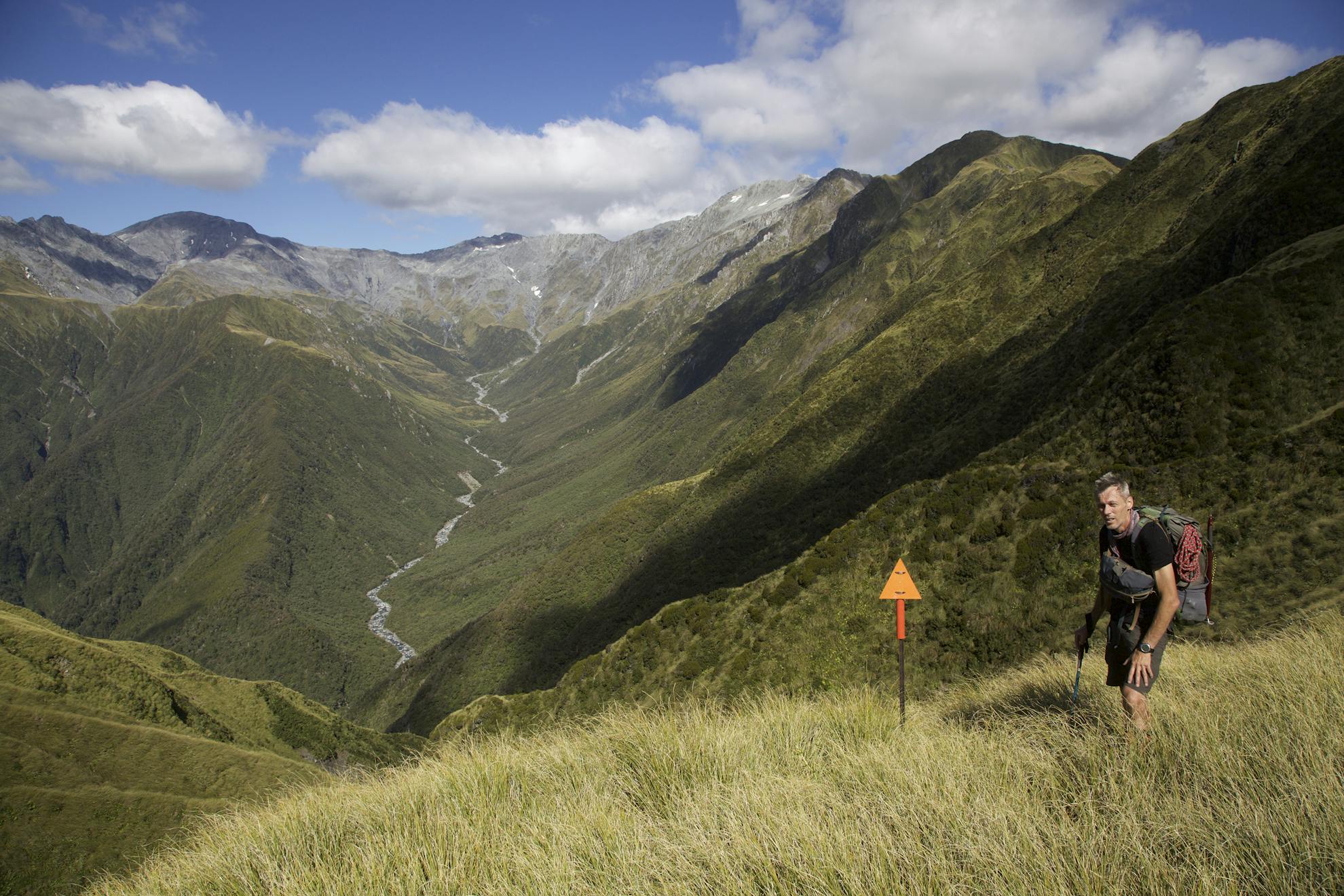
Day four was the crux of our route to Ivory Lake and it would stretch the definition of tramping. From Price Basin we headed up steep tussock towards Pt2056 on the Lange Range.
About two-thirds of the way up were two awkward rock outcrops. We traversed around the Price side of the first on ascending ledges and the tops of unstable scree slopes. I wouldn’t want to descend this way.
The second obstacle, a buttress, looked alarming from below but was a straightforward clamber at a fairly easy angle although a bit exposed. Above that, we cramponed up soft snow to a lunch spot perched over the brow of the range.
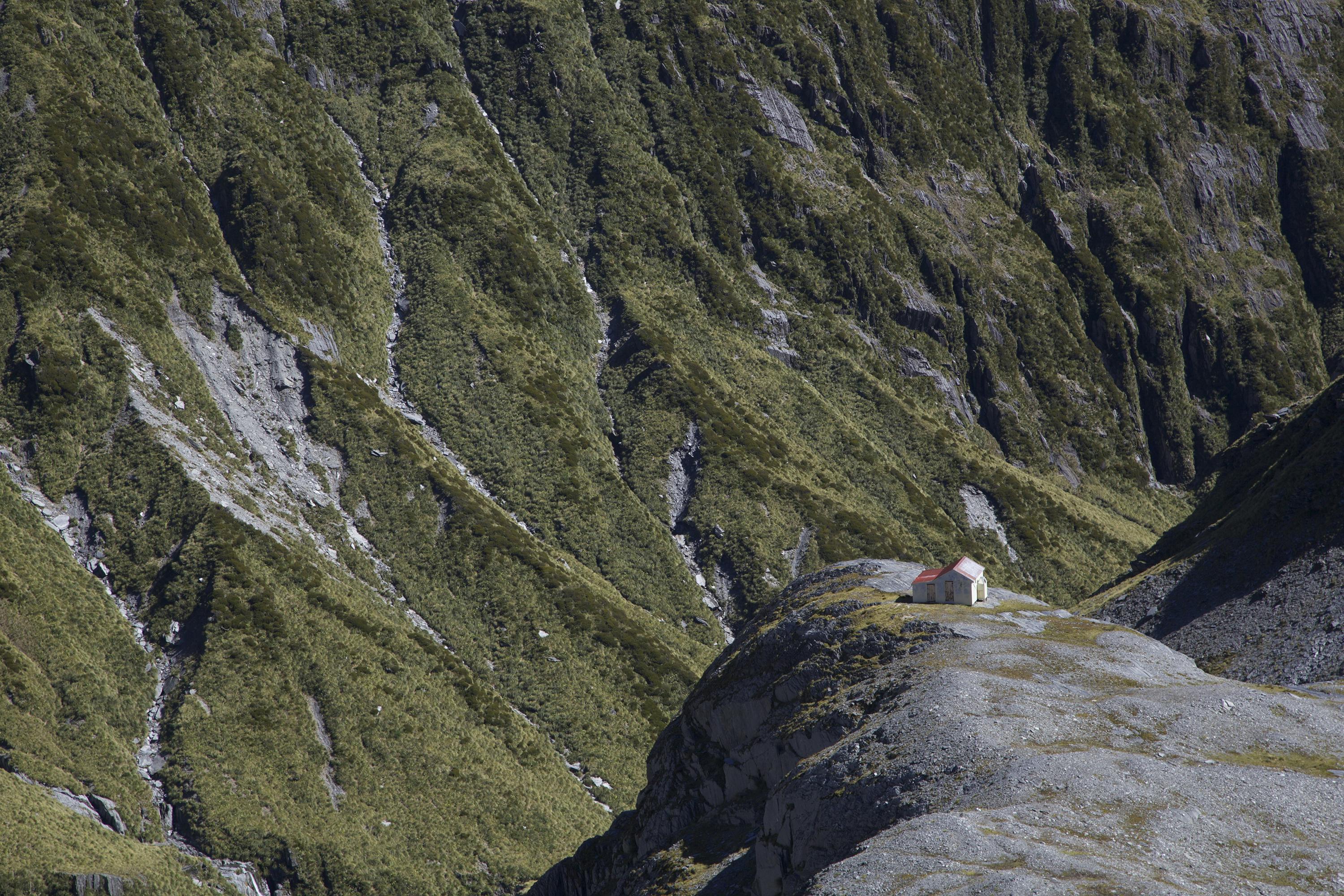
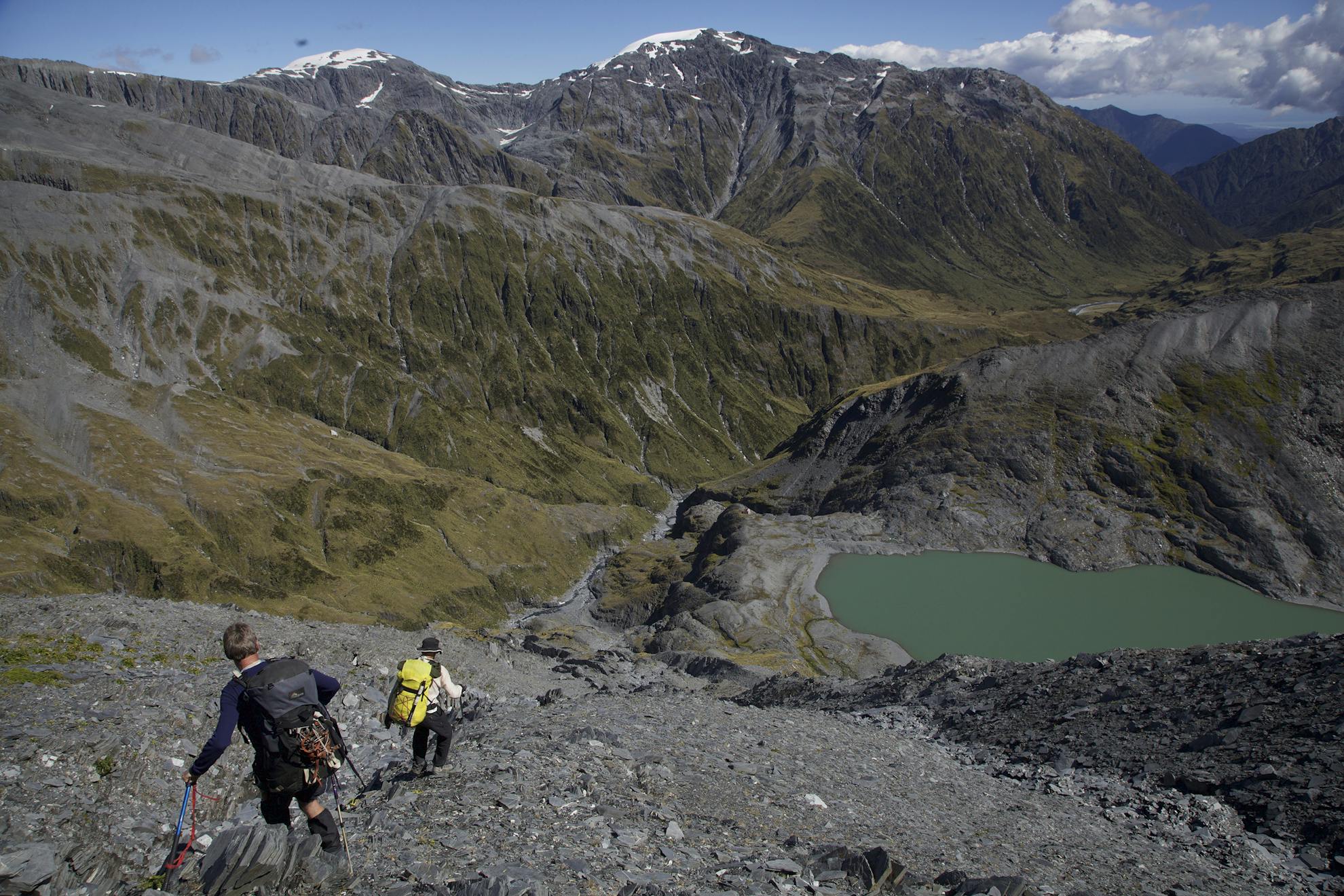
Ivory Lake Hut was a speck, just visible from the top if you squinted hard enough down the rocky slope that we knew would thrash our legs. We could glimpse the lake too and, around to the right, the shrinking glacier that was the reason for the construction of the hut in 1970 as a base for researchers.
Planted on a polished rock knoll on the lip of the lake basin, the hut, seen from a distance, looked to be almost hovering above Stag Creek, 100m below. At the hut, the lake view was framed by soaring mountainsides – on the right by our route in from the Lange Range and on the left by our route out, up to Sawtooth Ridge. Looking the other way, across the Waitaha headwaters, was the route to Park Dome, 2340m, up in the wispy clouds.
We hauled the hut’s much loved, much pictured, patched-up pink armchair outside for the obligatory photo shoot. The ‘chair of glaciology’ is said to have belonged to the late Trevor Chinn, who led the first research into the receding Ivory Glacier.
The six-bunk hut has been renovated by keen community members, including Chinn, who died last year. It is now a Department of Conservation/community initiative and the DOC website refers readers seeking information about the hut to Permolat’s comprehensive huts and routes site, remotehuts.co.nz.
But the fame of Ivory Lake Hut has also brought problems. Several parties have been rescued from the area. And now a helicopter operator has been flying people on scenic flights on a trial basis and is seeking an ongoing concession.
The operator has argued that people who can’t get there on foot should still have the opportunity and has promised not to land or fly low if trampers are visible there.
Permolat has expressed concern on its website about the flights, complaining of ‘the insidious creep of noise and activity into some of our prized remote destinations and wilderness spaces…. It’s a real challenge and achievement to reach Ivory Lake by foot and its isolation and remote ambience is what makes it unique’.
The only noise my group experienced was the whistling of Pam’s still cool northeasterly through a door which wouldn’t shut easily, and the rushing of the lake outlet stream into the headwaters of the Waitaha River.
We had a day up our sleeve for a rest or to climb Park Dome, but with the weather holding – it was the West Coast after all – we opted for just one night among the scenic wonders of Ivory Lake.
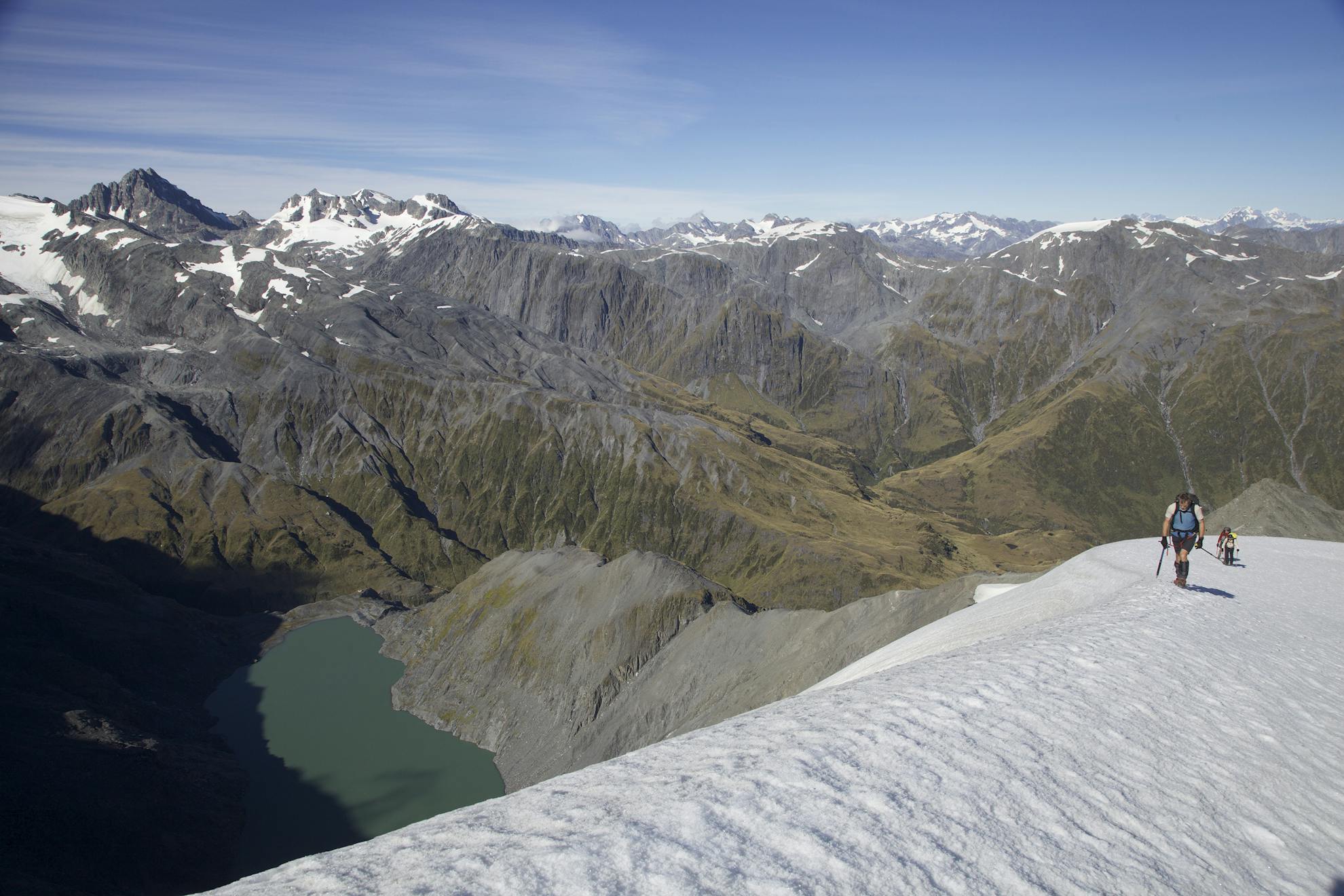
The climb up and around the western side of the lake was straightforward, with several steep sections. Higher up, our route wove around amazing Weetbix towers before heading onto an inwards-sloping ramp of firm snow to Pt2084. Cramponing up the ramp, we could peek over the snow’s lip down to the glacier, lake and hut far below.
Shortly after Pt2084, we used a rope for a 5m section to get back onto the ridge. The moves were easy, but the run-out onto scree was steep and looked unforgiving. Derek soloed the difficulty and, anchored by a loop around a spike of rock, brought up the three of us.
Feeling confident and thinking we had plenty of time, we detoured up to the snowy, flat top of Mt Beaumont (2118m), and enjoyed the expansive views north across the Hokitika Plain and far up the coast.
There followed a gap in the photographic record of this trip, from Mt Beaumont to Top Tuke Hut. I can, therefore, rely only on memory – and feelings, principally terror, but also bewilderment, exhaustion and camaraderie.
Our route notes directed us to a cairn at the junction of Sawtooth Ridge and our Beaumont Ridge, from which we were to follow a ‘broad spur’ down into the Tuke Valley. I like cairns. And who doesn’t like a broad spur? We found neither.
Derek, and particularly John, now took the lead, nosing us down one gully or spur after another, only to retreat after 50m or so as the terrain steepened alarmingly. Any sense of time had been lost. Suddenly, it was early evening and I was wondering if we would have to bivvy.
Eventually, John cracked it. And it was a broad spur too, at first anyway. Bluffed at half-height, we traversed to another spur, descended a rocky gully, and crossed steep chutes. In one of these chutes, a rock foot-hold popped out and I fell heavily but luckily didn’t tumble.
These last chutes landed us on the final spur, a grassy, earthy one that went down almost to the river. It was so steep you wouldn’t want to slip. My legs and ankles were starting to drift out of my control so I moved with great caution.
Arriving at the river at the 1300m contour I felt immense relief. We delighted in a quick guzzle of the clear, cold water before plunging on, over large boulders and through beautiful pools, for 45 minutes to four-bunk Top Tuke Hut. We arrived, spent, just on sunset.
The most difficult part of our journey now over, we relaxed a bit and had a sleep in, getting away at 10am.
Yet another fine day greeted us as we ambled (and struggled here and there) down the occasionally-marked track on the true left bank of the Tuke to above its gorge, where a cairned and later poled route pulled steeply up a creek and onto the tops of Dickie Ridge.
We devoured two nights and a day of R&R at four-bunk Dickie Spur Hut, which is slightly off the route and has a fine view of the upper Tuke Valley, Mt Beaumont and Galena Ridge.
Pam’s influence was at last finished. Light rain fell as the forest enveloped us for the descent of the steep, often slippery track from Dickie Ridge to Truran Pass and the lower Tuke Valley.
From the Tuke, it’s a short hop over a hill to Mikonui Flat Hut. We arrived in the early afternoon, giving Craig ample time to bake his delicious fruit bread. He and I had been sharing dinners, cooking turn about, until I objected to his home-dehy of overcooked broccoli and eggs, after which we both went solo. Graciously, he didn’t hold my tantrum against me when slicing his warm, crusty loaf and passing around butter and jam.
Two hunters joined us in the six-bunk hut and were treated to after-dinner bread. Next morning, when they headed out for a shoot, the last to leave locked us in the hut; we wondered what they had in store for us. Fortunately, there were louvre windows. We slid them out and one of us clambered out to unlock our prison.
We had a three and a half hour day in the murk up to Explorer Hut at Douglas Saddle, one of the areas where Permolat members have done hut and track work. On our last day, the track was easy to follow down to Doctor Creek but required some care while crossing over to the Hokitika River.
As we walked down the true left of the Hokitika, Derek strode ahead towards the gorge footbridge, while Craig and John hatched a plan to ford the mighty river, more than 50m across, ostensibly to trim 30 minutes off the return to the car. My excuse to avoid linking arms with them – and potentially having a swim – was that Derek needed to be told. The swift-flowing water looked to be nearly waist deep at mid-stream when I pressed on to catch Derek.
They were waiting at the car when Derek and I arrived after a brief bush-bash to find the gorge track.
Visiting Ivory Lake, a scenic gem I might never have seen, if not for a cyclone, tested my endurance to near its limit.
- Distance
- 75km
- Total Ascent
- 6123m
- Time
- Allow 8 to 10 days. Whitcombe Valley Rd to Frew Hut, 7hr; To Wilkinson Hut, 10hr; To Price Basin Hut, 9hr; To Ivory Lake Hut, 6-7hr; To Top Tuke Hut, 9hr; To Dickie Spur Hut, 7hr; To Mikonui Flat Hut, 4hr; To Explorer Hut, 3-4hr; To Whitcombe Valley Rd, 7hr
- Access
- Follow signs from Hokitika to Hokitika Gorge. Whitcombe Valley Road continues past the gorge car park to the Whitcombe Track car park about 1km further on
- Map
- BV18, BW18
GPX File
- Ivory Lake Hut (gpx, 34 KB)
GPX File
- Your device does not support GPX files. Please try a different device.
