


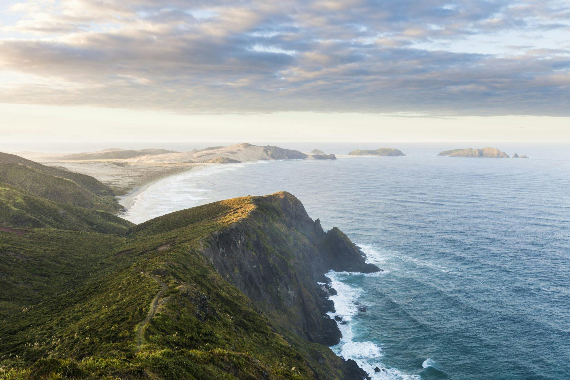


Beach-hopping coast-to-coast around the northern tip of New Zealand, the Te Paki Coastal Track is one of the best seaside tramps in the country.
Northland doesn’t spring to mind as a tramping destination for most New Zealanders, who probably first think of the area for its glorious beaches. However, in the far north, beaches and tramping combine to make one of the country’s best coastal walks.
The 44km Te Paki Coastal Track begins at Kapowairua/Spirits Bay, traverses around Te Rerenga Wairua/Cape Reinga, and south-westwards to Cape Maria van Diemen, before swinging south-east to reach Ninety Mile Beach. It ends at the sand dunes of Te Paki, some of the country’s most extensive. Of course, since 2011, the track has become the start of the Te Araroa Trail, now completed by hundreds of people every year.
Even in winter, the weather is usually mild, and for that reason there are no huts; just basic campsites. Spring and autumn offer good walking seasons, although casual trampers may want to avoid the former when most Te Araroa hikers begin their journey here. Summer can bring oppressively hot temperatures, but usually a coastal breeze helps cool things down. And there’s always the opportunity for a refreshing dip in the sea.
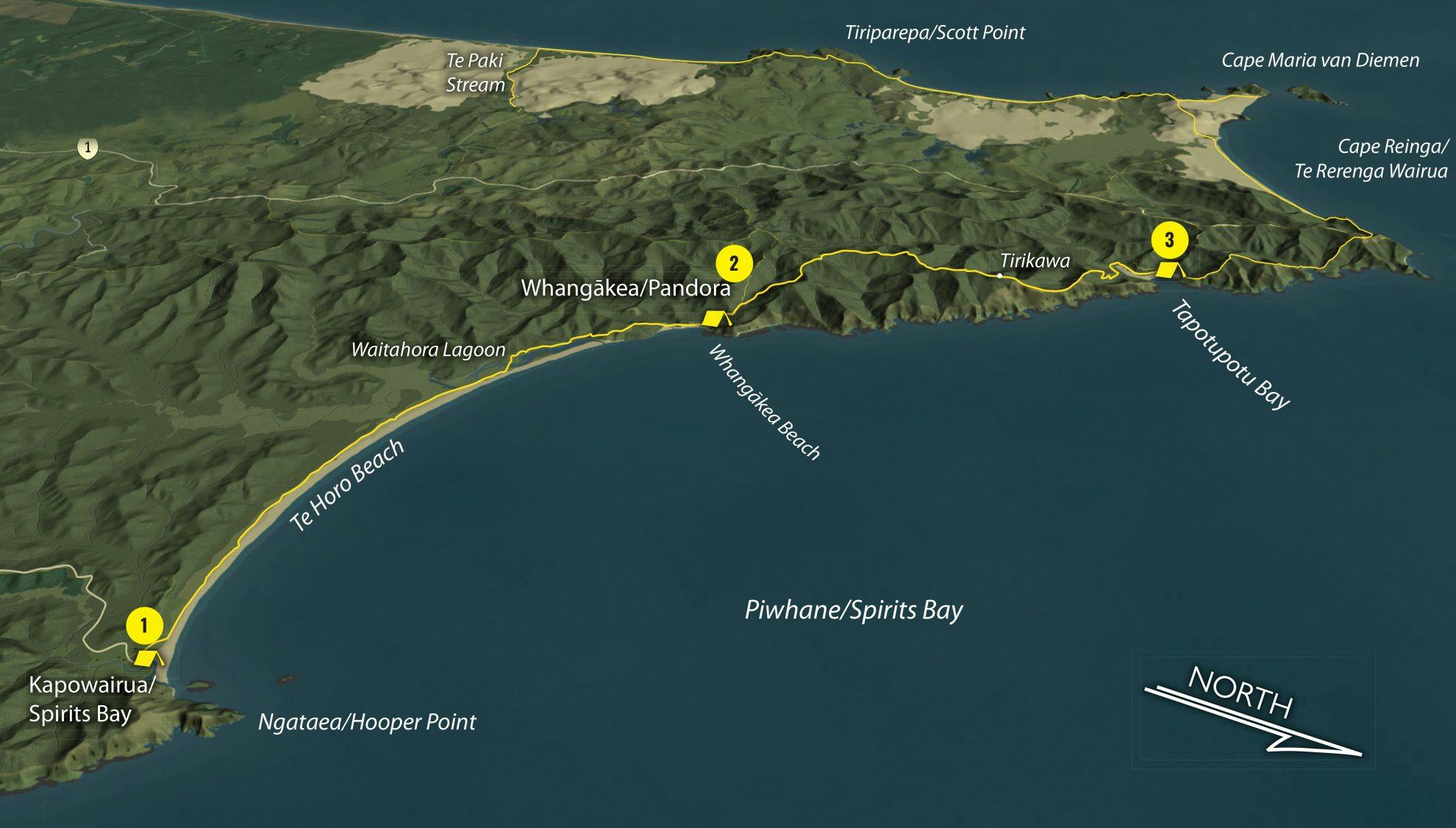
1. Kapowairua/Spirits Bay Campsite
The track begins on a broad sweep of Spirits Bay, almost 10km long, and traverses across the base of dunes with the startlingly blue sea ever present. Look out for dotterels, godwits and oystercatchers. At the beach’s western end, the track crosses the Waitahora Lagoon on a long boardwalk, before sidling across a forested ridge and then descending to Whangākea Beach. The Pandora Campsite lies slightly inland.
2. Pandora Campsite
From the campsite, the Te Paki track climbs out of the Whangākea Valley, until gaining a ridge some distance from the shoreline. This is one of the bigger climbs of the tramp, which otherwise has little climbing, but grand views of the coastal scenery offer plenty of compensation. For the next couple of hours, the track stays on the spine of the ridge, which is clothed in coastal vegetation, before reaching the old pa site at Tirikawa. Here the route descends to the coast once more, where it reaches Tapotupotu Bay and the campsite.
3. Tapotupotu Bay campsite
This campsite, lying just east of Cape Reinga, is also accessible by road, so offers another possible starting point for trampers with less time. Fringed by pohutukawa trees, and framed by coastal cliffs and reefs on either side, it’s a picturesque wee curl of a bay, with the Te Paki Coastal Track continuing at its western end.
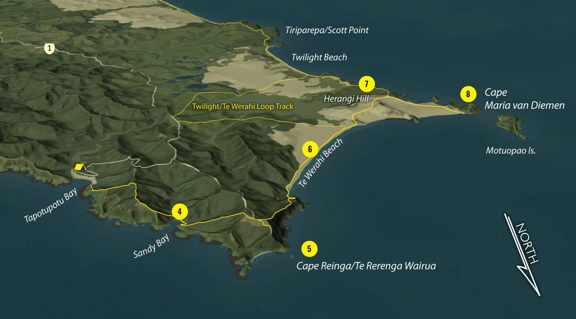
4. Sandy Bay
To avoid impassable cliffs, the track sidles high, climbing almost 200m before descending again to Sandy Bay, crossing a small stream and resuming a climb to perhaps the most famous headland in the country.
5. Cape Reinga/Te Rerenga Wairua
The renowned lighthouse and signpost of Cape Reinga have appeared in countless calendars, on postage stamps, and in movies. To Maori, this is the launching point of departed souls and a place of deep cultural significance.
It seems every New Zealander wants to visit Cape Reinga at some stage in their life, even if it is not – as popularly believed – the northernmost point of the country’s mainland (that honour belongs to the Hikurua/de Serville Cliffs of North Cape, lying 30km east). There’s something special about arriving here on foot, having earned the view with a bit of decent, honest sweat. Here, the Pacific Ocean and Tasman Sea meet in a clashing of currents and swells.
6. Te Werahi Beach
Beyond, the track swings south-westward, descending towards Te Werahi Beach – a wide sweep of sand and dunes that separates Cape Reinga from Cape Maria van Diemen. Following the shoreline, the route reaches Te Werahi Stream, which can be difficult to cross in flood, but normally presents nothing more than wet feet.
7. Herangi Hill
The track climbs, which can be hard work in the loose sand, to Herangi Hill, a curious mound of wind-sculpted sand and exposed ultramafic rock with fine views over Cape Maria van Diemen.
8. Cape Maria van Diemen
Dutch mariner Abel Tasman named this cape on his visit to Aotearoa in 1642-43. Like many before him and since, the name was a carefully chosen political one; by doing so, Abel Tasman acknowledged the wife of his benefactor, Anthony van Diemen. The cape is reached on a sidetrack from the main Te Paki route, which leads to an attractive rocky shore, with the Motuopao Island and its derelict lighthouse lying just offshore.
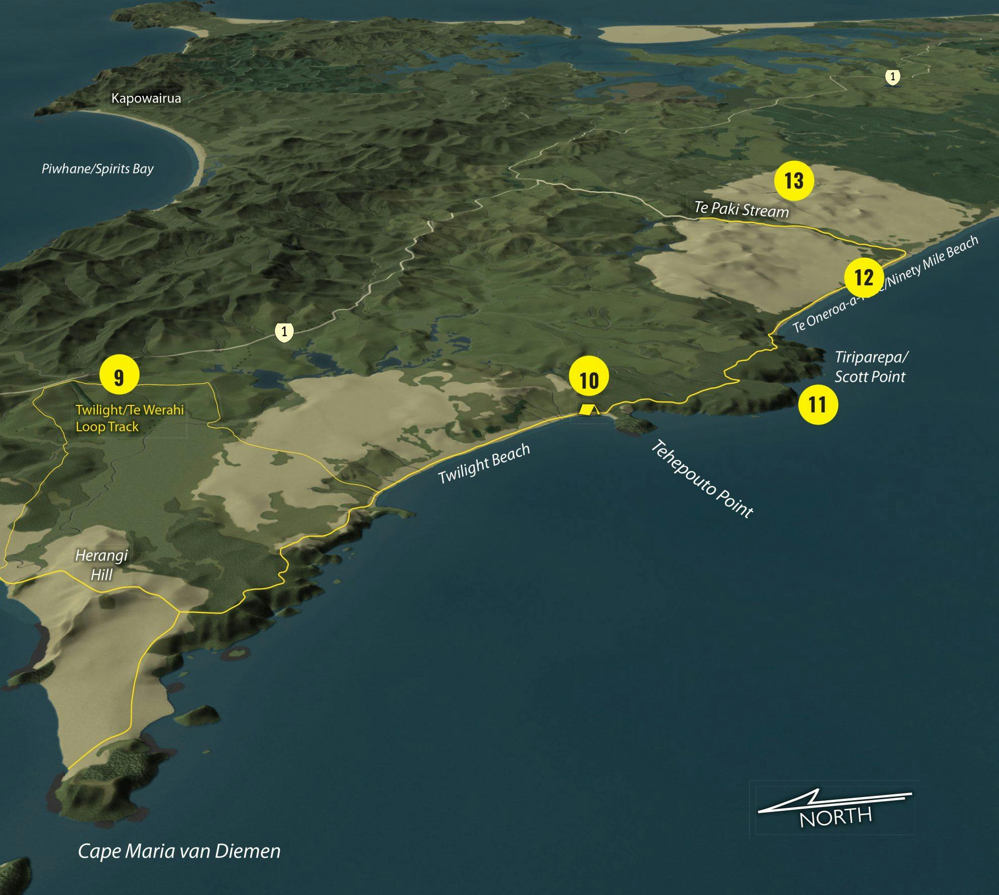
9. Twilight/Te Werahi Loop Track
For those with limited time, or those needing an escape route, this track leads back to SH1, passing through the wetlands of the Te Werahi Stream en route.
10. Twilight Beach and campsite
The main Te Paki track bends south, following a high terrace overlooking the bluffs of Maungatiketike Point. Wind-battered coastal plants eke out an uncertain existence in this harsh, often-parched terrain through which the track wends until a descent to Twilight Beach. The campsite lies at the far end of the beach.
11. Tiriparepa/Scott Point
From Twilight Beach campsite, the track climbs up over yet another headland, known as Tiriparepa or Scott Point. It separates Twilight Beach from its more famous and vastly longer Ninety Mile Beach/Te Oneroa-a-Tōhē. On a good day, views of the wide stretch of sand recede into the haze-softened distance, with the relentless breakers of the Tasman Sea foaming in.
12. Te Oneroa-a-Tōhē/Ninety Mile Beach
Low tide is certainly the best time to walk this section of the trail, when you can pick the firmest sand – usually that recently exposed by the retreating tide. Be warned, however, that walking on sand can be unexpectedly hard. The endless pounding on the unchanging surface can cause blisters, bruised feet, or both. Nevertheless, there’s a pleasing simplicity to this sort of strolling, breathing in the salty air without having to watch your feet.
13. Te Paki Stream and sand dunes
While Te Araroa hikers have the entire length of the beach to walk, those walking the Te Paki section turn inland after only 5km or so, where Te Paki Stream disgorges onto the shore. The route heads inland, following the stream, into what is possibly the highlight of the entire track – these extensive dunes. It’s well worth allowing enough time to wander in this landscape of sand mountains, which can easily swallow people, almost literally. Wind-rippled dunes, with writhing, serpent-like spines; steep sandy faces, exposed rocks and the sheer vastness of the dune system make this a place to marvel at the artistry of nature.
The track ends on the edge of the dunes, at Te Paki Stream Road car park.
- Distance
- 43.8km
- Total Ascent
- 1787m
- Grade
- Easy
- Time
- Spirits Bay to Pandora Campsite, 3hr; Pandora to Tapotupotu Bay campsite, 5.5hr; Tapotupotu to Cape Reinga, 2-2.5hr; To Herangi Hill, 2hr; Sidetrack to Cape Maria van Diemen, 90min return; To Twilight Beach campsite, 1.5hr; To Te Paki Stream Road via Te Paki Stream, 4-5hr
- Accom.
- Campsites at Pandora, Tapotupotu Bay and Twilight Beach
- Access
- From Spirits Bay Road end, 1hr45min drive from Kaitaia. A car shuttle is required or local operators can arrange pick-up/drop-off
- Map
- AT24
GPX File
- Te Paki (gpx, 57 KB)
GPX File
- Your device does not support GPX files. Please try a different device.
