


This spectacular traverse of the Tararua main range is an unforgettable experience.
The Tararua Range is punctuated by ‘classic’ tramps, routes trodden over many decades and memorialised in generations of photo albums. Of these routes, the southern and northern crossings are perhaps the best known. The most spectacular, though, would be the traverse of the main south range from Junction Knob to Bridge Peak. Add an off-track excursion into the rugged Snowy River and there’s a recipe for an unforgettable experience.
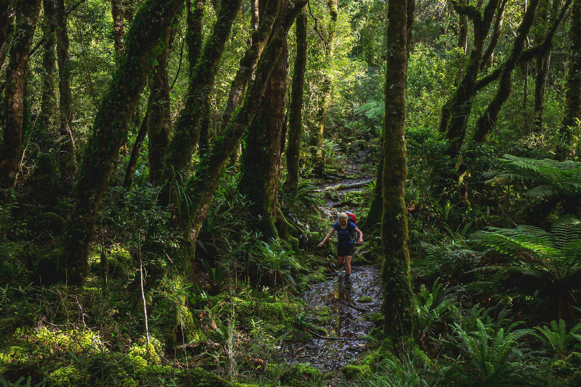
My friend Emily and I shouldered packs and began down the Ōtaki Gorge Road from Shields Flat. It was a hot morning in April. We were soon over the Ōtaki River swingbridge on the track to Waitewaewae Hut, but 500m along the track abruptly turned up the hill and lost all semblance of civility. We scratched up the slope, glad the ‘track’ wasn’t wet.
The reason for this detour was that a yawning chasm of a slip had consumed the track’s old path. The route to Waitewaewae used to follow an old bush tramway that carried logs to the Ōtaki River, where they would be dumped to float down to the sea. Alas, deforestation and subsequent grazing has resulted in a number of slips, with one just before Papa Creek completely obliterating the old alignment. The maintained track now sidles high above the Waitatapia and Saddle Creek with plenty of undulation to keep the heart pumping.
We began dropping to ‘the Plateau’, a long, flat basin between the Waitatapia and the upper Ōtaki, where we joined with the old track, crossed Plateau Stream and, on the far side, found a well-established campsite. Near the bottom of Aropito Creek a signpost marks a ‘high’ and ‘low’ route, with the latter continuing down to the Ōtaki on the true right. We decided to keep boots dry and steamed off up the hill, climbing 100m before dropping down to the Ōtaki River and Waitewaewae Hut. After a refreshing swim we settled in for the night, pondering the grunt up the range to come.
Next morning the world was cloaked in mist, the vague shapes of the surrounding hills only just visible. From Waitewaewae progress was swift to the bridge, where we crossed onto the true right of the Ōtaki. From here the track rose steeply, and contours ticked by slowly. Eventually we broke out of the bushline beneath Shoulder Knob, where we were greeted by a rare and spectacular panorama of the surrounding country, unobstructed by cloud. Even Taranaki Maunga was visible in the distance.
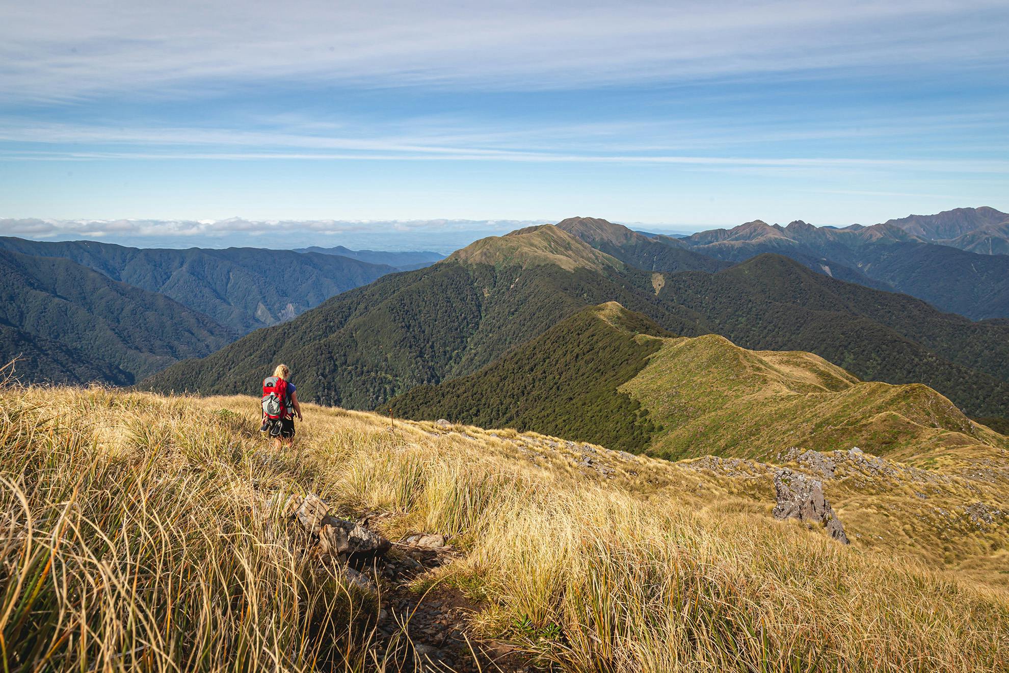
It was pleasing to reach Junction Knob, and we hoped the day’s elevation grunt was over. Hmm. In front the ridge seemed to carry on forever, linking the peaks of Kahiwiroa, Aokaparangi and Maungahuka. The one thing we couldn’t see were our feet, as monstrous tussock obscured the track’s soggy path. A series of muddy tarns marked the approach to Anderson Memorial Hut, which was tucked into the edge of a goblin forest. We perched on the seat outside the hut, digging out our snacks and refilling water bottles.
From the hut we were straight into the forest, where thick masses of moss molested every surface. After 1500m the forest ended and we were again on the open tops, climbing Kahiwiroa’s flanks in the scorching sun. From the top is the imposing form of Aokaparangi, and a quick peek into the valley revealed Mid-Waiohine Hut far below, one to bag another day.
We dropped 200m before beginning to rise on the far side – another 200m climb up to Aokaparangi. Emily was not inspired. It was mid-afternoon when we reached the summit signpost and Maungahuka was within our sights, albeit distantly. I opted to drop down to Aokaparangi Hut 200m below on the bushline, while Emily wisely continued in the direction of Maung- ahuka. I left my pack and checked out the hut before slogging back up the hill. Reunited with my load, I careered down the slope in the direction of Wright. The track was little more than a muddy slide flanked by tussock and flax. At the saddle between Wright and Simpson the ridge narrowed, necessitating a clamber above reasonably steep drop-offs. I caught Emily at Pt1174 and we began the final climb to Maungahuka. It was with great relief that we broached the ridgeline, finding on the far side an idyllic tarn with the hut’s reflection shimmering on its surface. The hut is a cosy sanctuary.
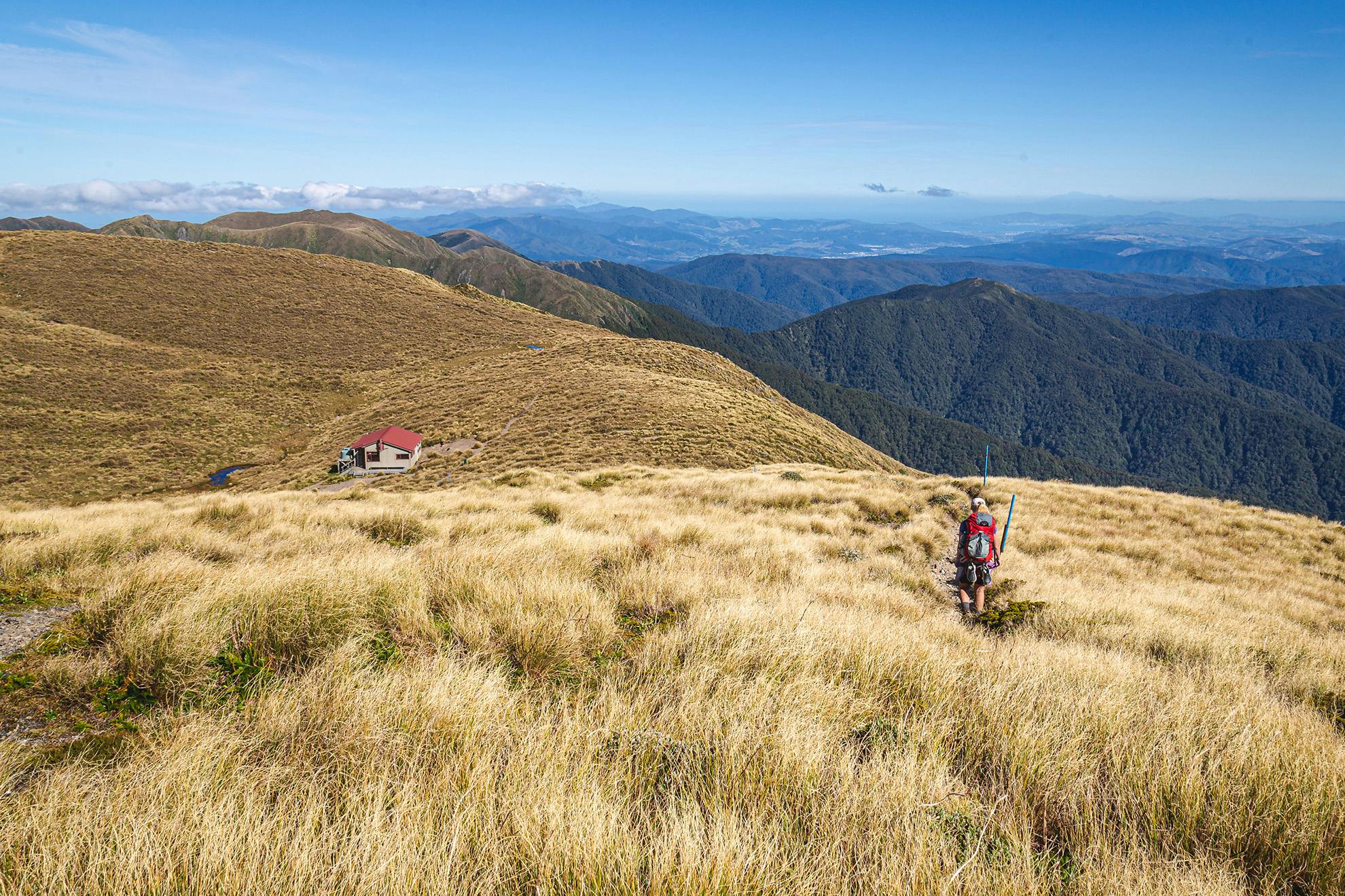
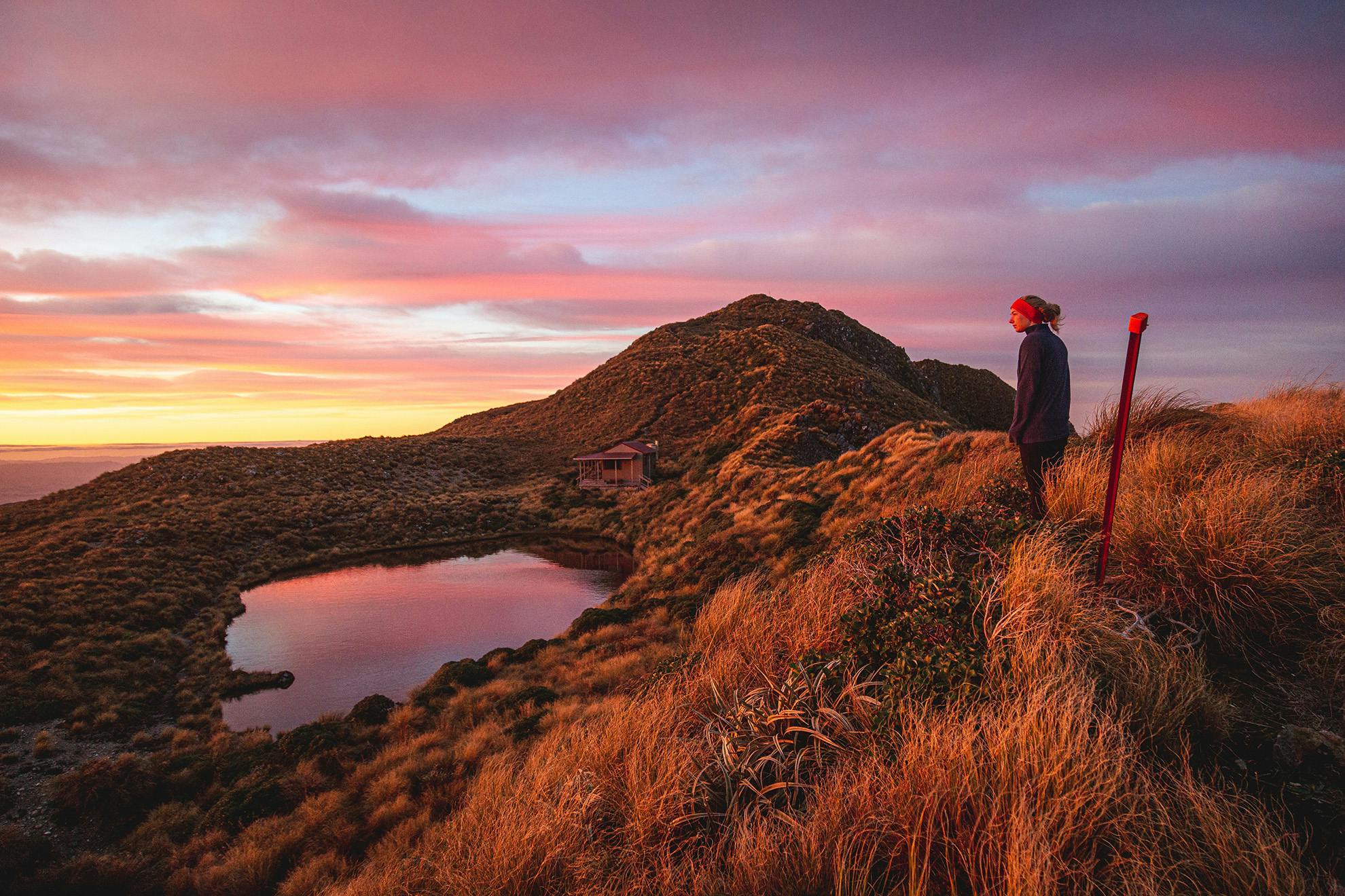
Emily dragged me out before 7am to watch the sky, which was dancing with the amber colours of sunrise. The landscape was painted orange. It was magical. Then, coffee and porridge and off, behind the hut, up Maungahuka (1330m). From its top we could see the twin Tararua peaks of Tuiti and Tunui. They looked impassable, their gnarled summits appearing as insurmountable obstacles. However, slowly but surely, we made our way up and around the shoulder of Tunui, helped by the infamous steel ladder. I wondered how this route could be achieved without it. At the top we clambered over a rocky knoll before climbing around Tuiti, where pretty much the rest of the morning’s walking was laid out before us: up, down, mud, up, down, mud. Yeates, Vosseler and Boyd-Wilson Knob were all knocked off with some determination, as was the 300m climb to the top of Bridge Peak until, at last, we were at empty Kime Hut.
We decided not to stay at Kime but head down into the Eastern Waiotauru Snowy River for our final night. We went southwest down the unmarked Tregear Spur, and were surprised at how open the bush was when we reached it. There were even a few markers. It all went well until we reached Pt594, from where we had to find a way to Snowy Hut on the true left bank of the Snowy River. I led us off the ridge and soon realised I had made a mistake. Emily swore at me as we alternated between vertical slides and sub-par sidles. The bush spat us out, cut up and exhausted, on the true right of the Snowy. On the far bank was Snowy Hut, a surprisingly welcoming place for an unofficial hut. The inside was tidy, and dry wood was stacked beside the fire.
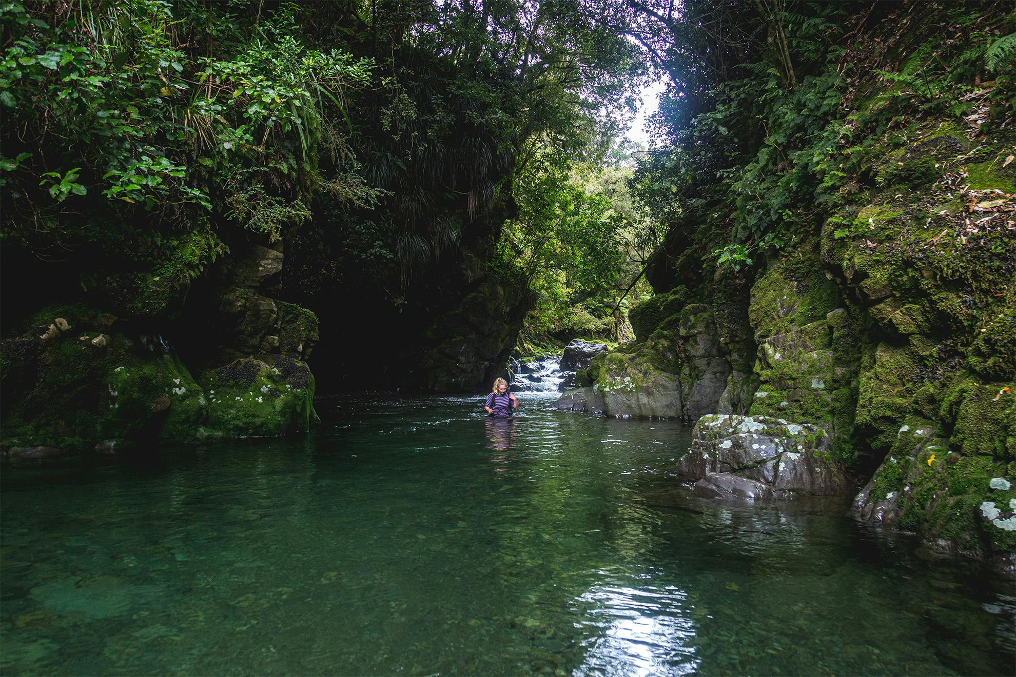
Next morning it was downriver towards the Waiotauru Track. Travel was easy, alternating between gravel shore and forest on either bank. We soon reached the confluence at the end of the ridge leading to Pt666, where there is a gorge. Two rock walls rise from the river to form a canyon that cradles an emerald-green pool. I gingerly stepped into the water and followed a gravel bank deeper and deeper. The water crept above my stomach. The flow was slow, my pack was floating, and with relief my feet found the far shore and I was soon high and dry, waiting for Emily. She seemed to find deeper bits, getting wet up to her armpits, but came out the other side all smiles. We continued down the river for another kilometre until the confluence with Tregear Creek, where we crossed to the true right of the Snowy. We picked up a route blazed with red tape before crossing the Tregear. On the far side we were on the remnants of a 1970s bulldozed logging road. This took us high above the river before dropping back to it. It ended at a bluff over the water just north of the side creek on the true left. We clambered carefully down this bluff before picking up the road on the far side, which connected us with the swingbridge over the Waiotauru.
We crossed to follow the track along the true left of the Waiotauru. It was mostly a good track, although several sections had experienced significant wash-outs resulting in uphill detours. Soon, though, we reached open country, with one final slip to clamber over before reaching the overgrown Ōtaki Forks Road. Our pace increased drastically, and it wasn’t long before we were at the car.
This traverse is not to be undertaken lightly. It features copious amounts of mud, multitudes of unnecessary climbs and descents and would be inhospitable in anything but the best weather. However, it has a particular type of charm that is hard to replicate, and for those game enough, it’s an unforgettable experience.
- Distance
- 57km
- Total Ascent
- 4500m
- Grade
- Difficult
- Time
- Road terminus to Waitewaewae Hut, 4.5hr; to Anderson Memorial Hut, 4hr; to Maungahuka Hut, 4.5hr; to Kime Hut, 4.5hr; to Snowy Hut, 4hr; to car park, 5hr
- Accom.
- Waitewaewae Hut (standard, 16 bunks), Anderson Memorial Hut (standard, six bunks), Aokaparangi Hut (basic, two bunks), Maungahuka Hut (standard, 10 bunks), Kime Hut (standard, 20 bunks), Snowy Hut (basic, two bunks)
- Access
- Ōtaki Forks Road
- Map
- BP33, BN33
