

A relaxing circuit in Mt Richmond Forest Park includes river rambling and attractive cascades, a lake and several huts.
Often we approach tramping like it’s a training schedule, a fitness programme or a ‘tick-the-box’ of completing another track. There’s nothing wrong with that, but it needn’t be that way. In the 1930s, ambitious speed trampers were dubbed ‘hissers’ by those enjoying a more sedate pace. The choice remains: tramp or toddle? Grunt or gambol? Stride or saunter? Hiss or hike?
On a trip into Marlborough’s Goulter Valley, Kathy Ombler and I chose to gambol – enjoying long lunches and a slow pace.
Storm damage scuppered plans to tramp the Paparoa Track, so we scoured maps to find tracks that might have escaped damage and where the weather might be reasonable. Perusing the ‘Patriarch’ map that covers the Richmond Range, I found a possible B-plan centred around the Goulter Valley and Lake Chalice. So, from a car park on Staircase Road, we planned to follow the vehicle track towards Mt Patriarch then the track to Mid Goulter Hut. After a day trip to Lower Goulter Hut and a second night at Mid Goulter we would continue up the Goulter Valley to Lake Chalice Hut to spend the night and exit to the car park at Staircase Road.
It looked like an easy to moderate, three to four-day, enticing and pleasant circuit. The forecast for eastern Marlborough was better than for surrounding places, and the trip covered ground that was new to both of us.
Although access on the narrow and convoluted Staircase Road is possible by 2WD as far as the Lake Chalice car park, I recommend taking a 4WD or mountain bike.
After lunch on a warm, sunny day with a strong northerly breeze, we shouldered packs and began our march along the vehicle track to Mt Patriarch (1656m), the highest peak on this particular ridge. The road follows a broad ridge flanked by wilding pines – not the most inspiring vegetation to tramp through, but we did gain excellent views of prominent local maunga: Mt Richmond, Johnson Peak, Ada Flat, both Rintouls and our ultimate destination, Lake Chalice, the only lake in Mt Richmond Forest Park. Viewed from above, it looked cool, blue and inviting.
Southwards were the innumerable peaks of the southern Marlborough ranges. Distinctive and most prominent were The Bounds, Pinnacle (which I had climbed a couple of years before), and Scotts Knob (still on the to-do list).
Arthritis in my toes had been painful on recent tramps, and although a new pair of boots was helping, the hard road surface gradually took its toll. Kathy kept me nicely distracted with her amiable conversation. After about 7km we reached a signposted junction. With no time for the extra 5km climb to Mt Patriarch, our desire for a leisurely schedule was already unfulfilled.

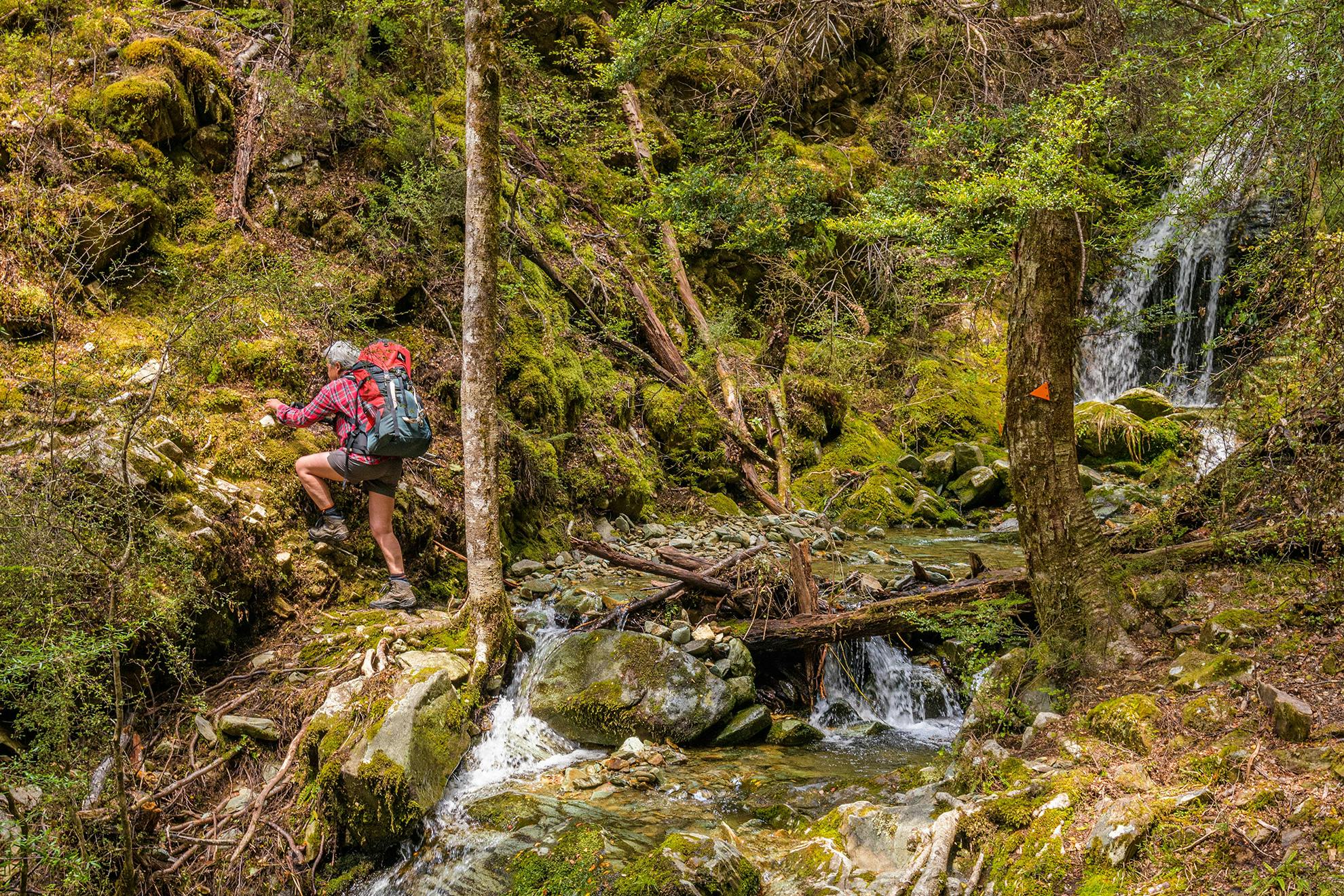
We began immediately down the steep route towards Mid Goulter Hut. The route, sidling across rocky ground, is marked by waratahs before joining a narrow spur studded by pole mountain beech. The sloping schist needed care. Further down came narrow sidling around several knolls covered with a mixture of stunted beech and pines. My walking pole helped to secure footing where loose rock skated under my boots. Covering terrain like this takes care and concentration, especially when you’re tiring.
At one point I glimpsed a skink scuttling off. Striped, brown and slinky, it was a beautiful reptile. In recent decades all sorts of new skink species have been discovered in our mountains, and I made a mental note to find out what this one might be – possibly a northern grass skink (Oligosoma polychrome).
When we finally reached the valley floor, our knees and feet were certainly ready for the flats. The last section, through beech and mānuka, brought us to the edge of the forest, beyond which was Mid Goulter Hut on a gentle grassy slope. Mt Patriarch towered beyond.
Mid Goulter was built in 1969 and was originally a standard four-bunk New Zealand Forest Service hut. In 1997 it was lifted from its foundations, hand-winched to a sunnier position 20m uphill, turned 180 degrees and rebuilt. Four more bunks and a verandah were added, and new windows and a wood stove were installed. During the 1990s DOC rangers Elwyn Wilson and Jake Anderson did this as well as maintaining and upgrading many huts in the area. With the hut to ourselves, Kathy and I settled in. I made fresh pasta with salmon and a Carbonara sauce, and Kathy produced Christmas cake and port.
The following morning we dozed through the enthusiastic dawn chorus put on by numerous bellbirds. Eventually, Kathy fossicked in her pack and proceeded to cook sausages, potatoes, mushrooms and bacon for breakfast. The wonders that come out of that pack! Replete, our laziness continued over several brews until – stirred by our own inertia – we packed lunch and enough gear for the day and headed down-valley towards Lower Goulter Hut.
This pleasant 8km stroll with light packs in good weather was a cruisy day to relish. The excellent track is mostly flat and follows the true left of the Goulter River, weaving through mossy stands of pole beech forest and crossing grassy flats. Where side streams spilled in we had views of boney Mt Patriarch and forested Mt Edelweiss rising on either side. After the recent storms the Goulter River was still flowing higher than normal – bank-to-bank in places. Just upstream of Lower Goulter Hut a short sidetrack to the top of a rocky knoll provided excellent views up-valley.
Lower Goulter Hut has the same eight-bunk layout as Mid Goulter, and is set close to the river on grassy flats. We continued our leisurely agenda by dozing and reading before returning to Mid Goulter Hut in the afternoon.
After a second night it was time to step up the pace and effort. Above Mid Goulter there is steep-sided terrain more typical of the Richmond Ranges. The track sidles high at times, often well away from the river. At the junction with the Old Man Track, we briefly contemplated tackling the big climb over Old Man, from where a track leads down to Lake Chalice, but the sky had darkened and thunder rumbled warningly.

So, in keeping with our indolent ways, we opted for the simple up-valley route direct to Lake Chalice. It was an excellent decision. By now the Goulter River had diminished to attractive cascades and the occasional waterfall. After around three hours we reached a fork where two fast-flowing tributaries merged, and here the track, now a rougher route, began to climb a prominent bouldery face where small streams sprang from between large rocks.
This was clearly the base of the huge landslide that formed Lake Chalice some 2000 years ago. It was thought to have been triggered by an earthquake which tumbled the ground down the slopes of Old Man to form a dam across the upper Goulter Valley. Water from the lake seeps through the dam, hence the spring-like flows we’d tramped past.
Landslides of this kind are not uncommon in the New Zealand mountains. I can think of at least five other lakes formed in the same manner: Daniel, Christabel (both near Lewis Pass), Green Lake (Fiordland), and Waikaremoana and Waikareiti (both in Te Urewera). More recently, lakes have formed in the Young (Mt Aspiring National Park) and Wangapeka (Kahurangi): beauty forged from destruction in the ever-changing nature of New Zealand’s dynamic maunga.
Near the crest of the rock dam was a surreal boundary with boulder jumbles on the left and a forested slope on the right, the precise edge of the boulder dam where it had come to rest.
The track skirted this boundary between boulder and beech. Smooth and easy footing led to the lake’s southern side after 40 minutes, and soon afterwards we reached Lake Chalice Hut. A brief, heavy downpour ensued, but not before we had sat down inside to enjoy cheese, crackers and tea. Perfect timing. We were relieved not to be traipsing over Old Man. Laziness rewarded?
Kōtare kingfishers called from their perches in trees overhanging Lake Chalice, and various waterfowl dabbled on the lake’s muddy margins. Welcome swallows swooped and dived, occasionally nipping an insect from the lake’s surface and leaving concentric ripples.
Shortly after dawn the skies opened and it began heaving down. This only encouraged our now daily ritual – coffee, breakfast, tea, reading. By the time we were packed and heading off it was 11am and the rain had eased – perhaps rewarding us for our laziness.
All that remained was an hour’s tramp back to Staircase Road on a track angled to stretch calf muscles. In Picton we listened to radio reports of the carnage caused by recent storms around the country. It seemed we had picked the only place in the country suitable for tramping. The easy-to-moderate trails and our relaxed schedule had been just what we both needed.
- Grade
- Moderate
- Time
- Car park to Mid Goulter Hut, 5–6hr; to Lower Goulter Hut, 5–6hr return; to Lake Chalice Hut, 5–6hr; to car park, 1–1.5hr
- Access
- Staircase Road, Lake Chalice car park. Check access is open, as forestry operations sometimes mean road closures.
- Map
- BR26